Zhaitang geodata
Zhaitang (Beijing) is a seat of a fourth-order administrative division; located in China in Asia/Shanghai (GMT+8) time zone. In our database, there are 1268 cities with bigger population. Compared to other cities in China, 86.3% of cities are located further ↓South; 58% of cities are located further ←West and 69.8% of cities have lower elevation than Zhaitang. Note1


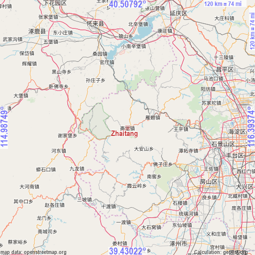
Zhaitang GPS coordinates[2]
39° 58' 16.284" North, 115° 41' 26.196" East
| Map corner | latitude | longitude |
|---|---|---|
| Upper-left | 40.50792°, | 114.98749° |
| Center: | 39.97119°, | 115.69061° |
| Lower-right: | 39.43022°, | 116.39374° |
| Map W x H: | 119.8×119.8 km | = 74.4×74.4mi |
| max Lat: | 53.31946° ⇑13.7% North |
| Zhaitang: | 39.97119° |
| min Lat: | ⇓86.3% South 18.22056° |
| min Long | Zhaitang | max Long |
| 75.07348° | 115.69061° | 134.28917° |
| W 58%⇐ | ⇒42% E |
Elevation
Elevation of Zhaitang is 408 m = 1339 ft, and this is 76.8 m = 252 ft below average elevation for this country.
| Max E: |
5622 m = 18445 ft | 30.2% |
| Avg. | 484.8 m = 1591 ft | |
| Zhaitang | 408 m = 1339 ft | |
Min E: |
-3 m = -10 ft | 69.8% |
See also: China elevation on elevation.city.
Geographical zone
Zhaitang is located in North temperate zone (between Tropic of Cancer and the Arctic Circle). Distance of this Northern Tropic circle is 1838.5 km =1142.4 mi to South.| Distance of | km | miles | from Zhaitang |
|---|---|---|---|
| North Pole | 5562.7 | 3456.5 | to North |
| Arctic Circle | 2956.8 | 1837.3 | to North |
| Tropic Cancer | 1838.5 | 1142.4 | to South |
| Equator | 4444.4 | 2761.6 | to South |


Nearby cities:
15 places around Zhaitang: (largest is in red/bold)
• Chengzi
34 km =21.1 mi,  93°
93°
• Da’anshan
12.1 km =7.5 mi,  141°
141°
• Hebei
26.8 km =16.7 mi,  130°
130°
• Junzhuang
34.4 km =21.4 mi,  84°
84°
• Miaofengshan
30.5 km =19 mi, 89°
• Nanjiao
26.3 km =16.3 mi,  150°
150°
• Puwa
29.2 km =18.1 mi,  207°
207°
• Qingshui
7.1 km =4.4 mi,  245°
245°
• Shijiaying
12.9 km =8 mi,  190°
190°
• Tanzhesi
30.8 km =19.1 mi,  110°
110°
• Wangping
24.8 km =15.4 mi, 91°
• Xiangyang
34.1 km =21.2 mi, 138°
• Xiayunling
27.7 km =17.2 mi,  171°
171°
• Yanchi
12.6 km =7.8 mi,  67°
67°
• Yanjiatai
11.4 km =7.1 mi,  286°
286°
Sources, notices
• [Note1] Compared only with cities in China existing in our database
• [Src1] Map data: © OpenStreetMap contributors (CC-BY-SA)
• [Src2] Other city data from geonames.org with taken over terms of usage.
• [Src3] Geographical zone / Annual Mean Temperature by Robert A. Rohde @ Wikipedia
