Pu’an geodata
Pu’an (Sichuan) is a seat of a fourth-order administrative division; located in China in Asia/Shanghai (GMT+8) time zone. In our database, there are 1268 cities with bigger population. Compared to other cities in China, 61.4% of cities are located further ↓South; 88.3% of cities are located further →East and 73.2% of cities have lower elevation than Pu’an. Note1


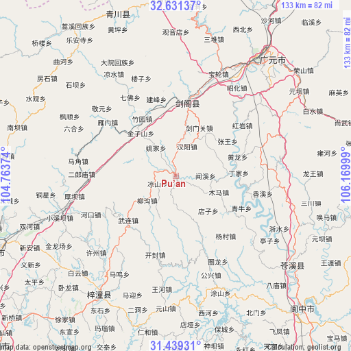
Pu’an GPS coordinates[2]
32° 2' 14.208" North, 105° 28' 0.696" East
| Map corner | latitude | longitude |
|---|---|---|
| Upper-left | 32.63137°, | 104.76374° |
| Center: | 32.03728°, | 105.46686° |
| Lower-right: | 31.43931°, | 106.16999° |
| Map W x H: | 132.5×132.5 km | = 82.3×82.3mi |
| max Lat: | 53.31946° ⇑38.6% North |
| Pu’an: | 32.03728° |
| min Lat: | ⇓61.4% South 18.22056° |
| min Long | Pu’an | max Long |
| 75.07348° | 105.46686° | 134.28917° |
| W 11.7%⇐ | ⇒88.3% E |
Elevation
Elevation of Pu’an is 480 m = 1575 ft, and this is 4.8 m = 16 ft below average elevation for this country.
| Max E: |
5622 m = 18445 ft | 26.8% |
| Avg. | 484.8 m = 1591 ft | |
| Pu’an | 480 m = 1575 ft | |
Min E: |
-3 m = -10 ft | 73.2% |
See also: China elevation on elevation.city.
Geographical zone
Pu’an is located in North temperate zone (between Tropic of Cancer and the Arctic Circle). Distance of this Northern Tropic circle is 956.3 km =594.2 mi to South.| Distance of | km | miles | from Pu’an |
|---|---|---|---|
| North Pole | 6444.9 | 4004.7 | to North |
| Arctic Circle | 3839 | 2385.4 | to North |
| Tropic Cancer | 956.3 | 594.2 | to South |
| Equator | 3562.2 | 2213.4 | to South |


Nearby cities:
15 places around Pu’an: (largest is in red/bold)
• Baishui
57.3 km =35.6 mi,  64°
64°
• Banqiao
66.1 km =41.1 mi,  350°
350°
• Dayuanhuizu
48.1 km =29.9 mi,  332°
332°
• Guangyuan
56.1 km =34.9 mi,  36°
36°
• Liangshui
45 km =28 mi, 328°
• Lingjiang
55.3 km =34.4 mi,  127°
127°
• Longwang
51.9 km =32.2 mi,  88°
88°
• Magong
52.1 km =32.4 mi,  308°
308°
• Qiaozhuang
65.3 km =40.6 mi,  340°
340°
• Qifo
34.2 km =21.3 mi, 329°
• Shangwu
66.8 km =41.5 mi,  72°
72°
• Suhe
45 km =28 mi,  321°
321°
• Wenchang
53.4 km =33.2 mi,  213°
213°
• Xiasi
28.4 km =17.6 mi,  8°
8°
• Yuanba
56.5 km =35.1 mi, 55°
Sources, notices
• [Note1] Compared only with cities in China existing in our database
• [Src1] Map data: © OpenStreetMap contributors (CC-BY-SA)
• [Src2] Other city data from geonames.org with taken over terms of usage.
• [Src3] Geographical zone / Annual Mean Temperature by Robert A. Rohde @ Wikipedia
