Tielu geodata
Tielu (Anhui) is a seat of a fourth-order administrative division; located in China in Asia/Shanghai (GMT+8) time zone. In our database, there are 1268 cities with bigger population. Compared to other cities in China, 58.5% of cities are located further ↑North; 64.4% of cities are located further ←West and 70.3% of cities have higher elevation than Tielu. Note1


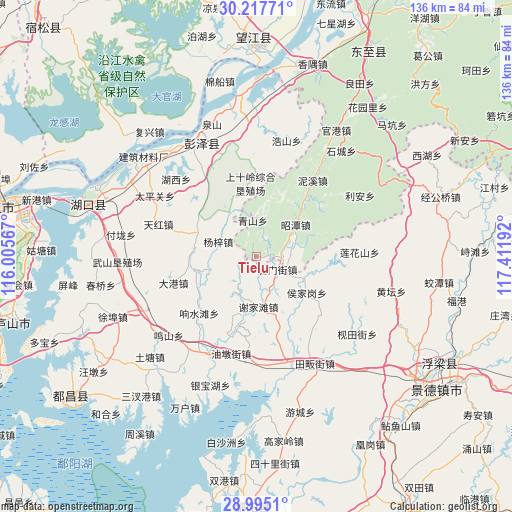
Tielu GPS coordinates[2]
29° 36' 29.736" North, 116° 42' 31.644" East
| Map corner | latitude | longitude |
|---|---|---|
| Upper-left | 30.21771°, | 116.00567° |
| Center: | 29.60826°, | 116.70879° |
| Lower-right: | 28.9951°, | 117.41192° |
| Map W x H: | 135.9×135.9 km | = 84.4×84.4mi |
| max Lat: | 53.31946° ⇑58.5% North |
| Tielu: | 29.60826° |
| min Lat: | ⇓41.5% South 18.22056° |
| min Long | Tielu | max Long |
| 75.07348° | 116.70879° | 134.28917° |
| W 64.4%⇐ | ⇒35.6% E |
Elevation
Elevation of Tielu is 51 m = 167 ft, and this is 433.8 m = 1423 ft below average elevation for this country.
| Max E: |
5622 m = 18445 ft | 70.3% |
| Avg. | 484.8 m = 1591 ft | |
| Tielu | 51 m = 167 ft | |
Min E: |
-3 m = -10 ft | 29.7% |
See also: China elevation on elevation.city.
Geographical zone
Tielu is located in North temperate zone (between Tropic of Cancer and the Arctic Circle). Distance of this Northern Tropic circle is 686.2 km =426.4 mi to South.| Distance of | km | miles | from Tielu |
|---|---|---|---|
| North Pole | 6714.9 | 4172.4 | to North |
| Arctic Circle | 4109 | 2553.2 | to North |
| Tropic Cancer | 686.2 | 426.4 | to South |
| Equator | 3292.1 | 2045.6 | to South |


Nearby cities:
15 places around Tielu: (largest is in red/bold)
• Dagang
22.9 km =14.2 mi,  252°
252°
• Dongsheng
24.7 km =15.3 mi,  357°
357°
• Houjiagang
16.4 km =10.2 mi,  125°
125°
• Huangling
25.4 km =15.8 mi,  326°
326°
• Lianhuashan
27.4 km =17 mi,  87°
87°
• Longquan
10.7 km =6.6 mi,  70°
70°
• Nixi
25.4 km =15.8 mi,  36°
36°
• Qingshan
9.6 km =6 mi,  353°
353°
• Shimenjie
6.6 km =4.1 mi,  121°
121°
• Tianhong
27.5 km =17.1 mi,  287°
287°
• Xiangshuitang
21.4 km =13.3 mi,  225°
225°
• Xiejiatan
13.4 km =8.3 mi,  178°
178°
• Yangzi
10.8 km =6.7 mi, 289°
• Youdunjie
26.6 km =16.5 mi,  195°
195°
• Zhegang
29.3 km =18.2 mi, 175°
Sources, notices
• [Note1] Compared only with cities in China existing in our database
• [Src1] Map data: © OpenStreetMap contributors (CC-BY-SA)
• [Src2] Other city data from geonames.org with taken over terms of usage.
• [Src3] Geographical zone / Annual Mean Temperature by Robert A. Rohde @ Wikipedia
