Ningdun geodata
Ningdun (Anhui) is a seat of a fourth-order administrative division; located in China in Asia/Shanghai (GMT+8) time zone. In our database, there are 1268 cities with bigger population. Compared to other cities in China, 50.1% of cities are located further ↓South; 76.6% of cities are located further ←West and 55.2% of cities have higher elevation than Ningdun. Note1


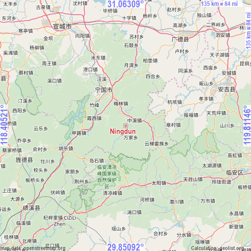
Ningdun GPS coordinates[2]
30° 27' 32.004" North, 119° 6' 29.988" East
| Map corner | latitude | longitude |
|---|---|---|
| Upper-left | 31.06309°, | 118.40521° |
| Center: | 30.45889°, | 119.10833° |
| Lower-right: | 29.85092°, | 119.81146° |
| Map W x H: | 134.8×134.8 km | = 83.8×83.8mi |
| max Lat: | 53.31946° ⇑49.9% North |
| Ningdun: | 30.45889° |
| min Lat: | ⇓50.1% South 18.22056° |
| min Long | Ningdun | max Long |
| 75.07348° | 119.10833° | 134.28917° |
| W 76.6%⇐ | ⇒23.4% E |
Elevation
Elevation of Ningdun is 130 m = 427 ft, and this is 354.8 m = 1164 ft below average elevation for this country.
| Max E: |
5622 m = 18445 ft | 55.2% |
| Avg. | 484.8 m = 1591 ft | |
| Ningdun | 130 m = 427 ft | |
Min E: |
-3 m = -10 ft | 44.8% |
See also: China elevation on elevation.city.
Geographical zone
Ningdun is located in North temperate zone (between Tropic of Cancer and the Arctic Circle). Distance of this Northern Tropic circle is 780.8 km =485.2 mi to South.| Distance of | km | miles | from Ningdun |
|---|---|---|---|
| North Pole | 6620.4 | 4113.7 | to North |
| Arctic Circle | 4014.5 | 2494.5 | to North |
| Tropic Cancer | 780.8 | 485.2 | to South |
| Equator | 3386.7 | 2104.4 | to South |


Nearby cities:
15 places around Ningdun: (largest is in red/bold)
• Daoshi
24.1 km =15 mi,  219°
219°
• Helixi
22.4 km =13.9 mi,  327°
327°
• Honglong
10.9 km =6.8 mi,  294°
294°
• Jialu
25.4 km =15.8 mi,  261°
261°
• Meilin
12.3 km =7.6 mi,  347°
347°
• Wanjia
6.5 km =4 mi,  158°
158°
• Xiaxi
17.4 km =10.8 mi, 285°
• Yalukou
24.2 km =15 mi,  338°
338°
• Yejia
18.1 km =11.2 mi,  108°
108°
• Yunti
19.1 km =11.9 mi,  119°
119°
• Yutiao
20.6 km =12.8 mi,  203°
203°
• Zhangcun
25.6 km =15.9 mi,  88°
88°
• Zhongxi
5.7 km =3.5 mi,  57°
57°
• Zhufeng
20.5 km =12.7 mi,  306°
306°
• Zhujiaqiao
7.7 km =4.8 mi,  210°
210°
Sources, notices
• [Note1] Compared only with cities in China existing in our database
• [Src1] Map data: © OpenStreetMap contributors (CC-BY-SA)
• [Src2] Other city data from geonames.org with taken over terms of usage.
• [Src3] Geographical zone / Annual Mean Temperature by Robert A. Rohde @ Wikipedia
