Nanpi geodata
Nanpi (Hebei) is a seat of a third-order administrative division; located in China in Asia/Shanghai (GMT+8) time zone. In our database, there are 1268 cities with bigger population. Compared to other cities in China, 81% of cities are located further ↓South; 64.3% of cities are located further ←West and 87.7% of cities have higher elevation than Nanpi. Note1


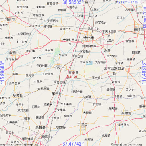
Nanpi GPS coordinates[2]
38° 1' 59.988" North, 116° 42' 0" East
| Map corner | latitude | longitude |
|---|---|---|
| Upper-left | 38.58505°, | 115.99688° |
| Center: | 38.03333°, | 116.7° |
| Lower-right: | 37.47742°, | 117.40313° |
| Map W x H: | 123.2×123.2 km | = 76.6×76.6mi |
| max Lat: | 53.31946° ⇑19% North |
| Nanpi: | 38.03333° |
| min Lat: | ⇓81% South 18.22056° |
| min Long | Nanpi | max Long |
| 75.07348° | 116.7° | 134.28917° |
| W 64.3%⇐ | ⇒35.7% E |
Elevation
Elevation of Nanpi is 12 m = 39 ft, and this is 472.8 m = 1551 ft below average elevation for this country.
| Max E: |
5622 m = 18445 ft | 87.7% |
| Avg. | 484.8 m = 1591 ft | |
| Nanpi | 12 m = 39 ft | |
Min E: |
-3 m = -10 ft | 12.3% |
See also: China elevation on elevation.city.
Geographical zone
Nanpi is located in North temperate zone (between Tropic of Cancer and the Arctic Circle). Distance of this Northern Tropic circle is 1623 km =1008.5 mi to South.| Distance of | km | miles | from Nanpi |
|---|---|---|---|
| North Pole | 5778.2 | 3590.4 | to North |
| Arctic Circle | 3172.3 | 1971.2 | to North |
| Tropic Cancer | 1623 | 1008.5 | to South |
| Equator | 4228.9 | 2627.7 | to South |


Nearby cities:
15 places around Nanpi: (largest is in red/bold)
• Botou
12.3 km =7.6 mi,  287°
287°
• Cangzhou
34.7 km =21.6 mi,  24°
24°
• Dengmingsi
15.1 km =9.4 mi,  166°
166°
• Dezhou
73.2 km =45.5 mi,  207°
207°
• Dongguang
22.1 km =13.7 mi,  221°
221°
• Duancun
66 km =41 mi, 292°
• Fucheng
51.5 km =32 mi,  249°
249°
• Jingzhou
54.4 km =33.8 mi,  225°
225°
• Lingcheng
78.9 km =49 mi,  188°
188°
• Ningjin
43.4 km =27 mi, 169°
• Sangyuan
53.2 km =33.1 mi, 211°
• Xiaowangzhuang
89.1 km =55.4 mi,  26°
26°
• Xinhu
74.2 km =46.1 mi, 208°
• Xizhaizhuang
86.1 km =53.5 mi, 17°
• Yangxin
88.3 km =54.9 mi,  119°
119°
Sources, notices
• [Note1] Compared only with cities in China existing in our database
• [Src1] Map data: © OpenStreetMap contributors (CC-BY-SA)
• [Src2] Other city data from geonames.org with taken over terms of usage.
• [Src3] Geographical zone / Annual Mean Temperature by Robert A. Rohde @ Wikipedia
