Botou geodata
Botou (Hebei) is a populated place; located in China in Asia/Shanghai (GMT+8) time zone. With population of 63,045 people, there are 685 cities with bigger population in this country. Compared to other cities in China, 81% of cities are located further ↓South; 63.5% of cities are located further ←West and 84.3% of cities have higher elevation than Botou. Note1


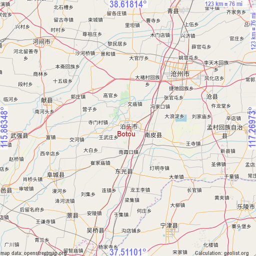
Botou GPS coordinates[2]
38° 4' 0.012" North, 116° 33' 59.76" East
| Map corner | latitude | longitude |
|---|---|---|
| Upper-left | 38.61814°, | 115.86348° |
| Center: | 38.06667°, | 116.5666° |
| Lower-right: | 37.51101°, | 117.26973° |
| Map W x H: | 123.1×123.1 km | = 76.5×76.5mi |
| max Lat: | 53.31946° ⇑19% North |
| Botou: | 38.06667° |
| min Lat: | ⇓81% South 18.22056° |
| min Long | Botou | max Long |
| 75.07348° | 116.5666° | 134.28917° |
| W 63.5%⇐ | ⇒36.5% E |
Elevation
Elevation of Botou is 17 m = 56 ft, and this is 467.8 m = 1535 ft below average elevation for this country.
| Max E: |
5622 m = 18445 ft | 84.3% |
| Avg. | 484.8 m = 1591 ft | |
| Botou | 17 m = 56 ft | |
Min E: |
-3 m = -10 ft | 15.7% |
See also: Botou elevation on elevation.city.
Geographical zone
Botou is located in North temperate zone (between Tropic of Cancer and the Arctic Circle). Distance of this Northern Tropic circle is 1626.7 km =1010.8 mi to South.| Distance of | km | miles | from Botou |
|---|---|---|---|
| North Pole | 5774.4 | 3588 | to North |
| Arctic Circle | 3168.6 | 1968.9 | to North |
| Tropic Cancer | 1626.7 | 1010.8 | to South |
| Equator | 4232.6 | 2630 | to South |


Nearby cities:
15 places around Botou: (largest is in red/bold)
• Cangzhou
38.2 km =23.7 mi,  43°
43°
• Dengmingsi
23.9 km =14.9 mi,  140°
140°
• Dezhou
72 km =44.7 mi,  198°
198°
• Dongguang
20.4 km =12.7 mi,  188°
188°
• Duancun
53.8 km =33.4 mi,  293°
293°
• Fucheng
42.6 km =26.5 mi,  238°
238°
• Hengshui
84.6 km =52.6 mi, 243°
• Jingzhou
49.9 km =31 mi,  212°
212°
• Lingcheng
81.8 km =50.8 mi,  179°
179°
• Nanpi
12.3 km =7.6 mi,  107°
107°
• Ningjin
50.4 km =31.3 mi,  156°
156°
• Renqiu
81.5 km =50.6 mi,  329°
329°
• Sangyuan
51.6 km =32.1 mi, 198°
• Xinhu
72.9 km =45.3 mi, 198°
• Xizhaizhuang
86.9 km =54 mi,  25°
25°
Sources, notices
• [Note1] Compared only with cities in China existing in our database
• [Src1] Map data: © OpenStreetMap contributors (CC-BY-SA)
• [Src2] Other city data from geonames.org with taken over terms of usage.
• [Src3] Geographical zone / Annual Mean Temperature by Robert A. Rohde @ Wikipedia
