Duancun geodata
Duancun (Hebei) is a seat of a fourth-order administrative division; located in China in Asia/Shanghai (GMT+8) time zone. In our database, there are 1268 cities with bigger population. Compared to other cities in China, 81.4% of cities are located further ↓South; 60.1% of cities are located further ←West and 84.3% of cities have higher elevation than Duancun. Note1


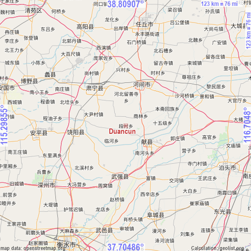
Duancun GPS coordinates[2]
38° 15' 32.616" North, 116° 0' 6.012" East
| Map corner | latitude | longitude |
|---|---|---|
| Upper-left | 38.80907°, | 115.29855° |
| Center: | 38.25906°, | 116.00167° |
| Lower-right: | 37.70486°, | 116.7048° |
| Map W x H: | 122.8×122.8 km | = 76.3×76.3mi |
| max Lat: | 53.31946° ⇑18.6% North |
| Duancun: | 38.25906° |
| min Lat: | ⇓81.4% South 18.22056° |
| min Long | Duancun | max Long |
| 75.07348° | 116.00167° | 134.28917° |
| W 60.1%⇐ | ⇒39.9% E |
Elevation
Elevation of Duancun is 17 m = 56 ft, and this is 467.8 m = 1535 ft below average elevation for this country.
| Max E: |
5622 m = 18445 ft | 84.3% |
| Avg. | 484.8 m = 1591 ft | |
| Duancun | 17 m = 56 ft | |
Min E: |
-3 m = -10 ft | 15.7% |
See also: China elevation on elevation.city.
Geographical zone
Duancun is located in North temperate zone (between Tropic of Cancer and the Arctic Circle). Distance of this Northern Tropic circle is 1648.1 km =1024.1 mi to South.| Distance of | km | miles | from Duancun |
|---|---|---|---|
| North Pole | 5753.1 | 3574.8 | to North |
| Arctic Circle | 3147.2 | 1955.6 | to North |
| Tropic Cancer | 1648.1 | 1024.1 | to South |
| Equator | 4254 | 2643.3 | to South |


Nearby cities:
15 places around Duancun: (largest is in red/bold)
• Baoding
79.4 km =49.3 mi,  325°
325°
• Botou
53.8 km =33.4 mi,  113°
113°
• Cangzhou
75.8 km =47.1 mi,  85°
85°
• Dengmingsi
76 km =47.2 mi,  121°
121°
• Dingzhou
92.1 km =57.2 mi,  287°
287°
• Dongguang
62.4 km =38.8 mi,  131°
131°
• Fucheng
45.3 km =28.1 mi,  163°
163°
• Gaopeng
88.6 km =55.1 mi,  276°
276°
• Hengshui
64.2 km =39.9 mi,  204°
204°
• Jingzhou
67.3 km =41.8 mi, 160°
• Nanpi
66 km =41 mi, 112°
• Renqiu
49.6 km =30.8 mi,  9°
9°
• Sangyuan
78 km =48.5 mi,  154°
154°
• Xinji
80.3 km =49.9 mi,  240°
240°
• Xizhong
92.9 km =57.7 mi,  273°
273°
Sources, notices
• [Note1] Compared only with cities in China existing in our database
• [Src1] Map data: © OpenStreetMap contributors (CC-BY-SA)
• [Src2] Other city data from geonames.org with taken over terms of usage.
• [Src3] Geographical zone / Annual Mean Temperature by Robert A. Rohde @ Wikipedia
