Meixian geodata
Meixian (Fujian) is a seat of a fourth-order administrative division; located in China in Asia/Shanghai (GMT+8) time zone. In our database, there are 1268 cities with bigger population. Compared to other cities in China, 81.4% of cities are located further ↑North; 71.7% of cities are located further ←West and 58.5% of cities have higher elevation than Meixian. Note1


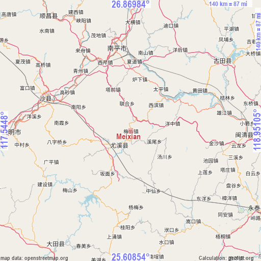
Meixian GPS coordinates[2]
26° 14' 27.24" North, 118° 14' 52.512" East
| Map corner | latitude | longitude |
|---|---|---|
| Upper-left | 26.86984°, | 117.5448° |
| Center: | 26.2409°, | 118.24792° |
| Lower-right: | 25.60854°, | 118.95105° |
| Map W x H: | 140.2×140.2 km | = 87.1×87.1mi |
| max Lat: | 53.31946° ⇑81.4% North |
| Meixian: | 26.2409° |
| min Lat: | ⇓18.6% South 18.22056° |
| min Long | Meixian | max Long |
| 75.07348° | 118.24792° | 134.28917° |
| W 71.7%⇐ | ⇒28.3% E |
Elevation
Elevation of Meixian is 108 m = 354 ft, and this is 376.8 m = 1236 ft below average elevation for this country.
| Max E: |
5622 m = 18445 ft | 58.5% |
| Avg. | 484.8 m = 1591 ft | |
| Meixian | 108 m = 354 ft | |
Min E: |
-3 m = -10 ft | 41.5% |
See also: China elevation on elevation.city.
Geographical zone
Meixian is located in North temperate zone (between Tropic of Cancer and the Arctic Circle). Distance of this Northern Tropic circle is 311.8 km =193.7 mi to South.| Distance of | km | miles | from Meixian |
|---|---|---|---|
| North Pole | 7089.3 | 4405.1 | to North |
| Arctic Circle | 4483.5 | 2785.9 | to North |
| Tropic Cancer | 311.8 | 193.7 | to South |
| Equator | 2917.7 | 1813 | to South |


Nearby cities:
15 places around Meixian: (largest is in red/bold)
• Banmian
26.3 km =16.3 mi,  209°
209°
• Guanqian
29.4 km =18.3 mi,  256°
256°
• Luxia
28.1 km =17.5 mi,  9°
9°
• Nanyang
30.9 km =19.2 mi,  294°
294°
• Tadou
14.6 km =9.1 mi,  352°
352°
• Taiping
28.4 km =17.6 mi,  36°
36°
• Taixi
15.5 km =9.6 mi,  180°
180°
• Tangchuan
22.7 km =14.1 mi,  128°
128°
• Xibin
19 km =11.8 mi, 41°
• Xicheng
13.7 km =8.5 mi,  230°
230°
• Xiwei
13.8 km =8.6 mi,  114°
114°
• Youxi Chengguanzhen
10.2 km =6.3 mi,  222°
222°
• Youxikou
26.2 km =16.3 mi,  48°
48°
• Zhanghuban
28.6 km =17.8 mi,  55°
55°
• Zhenghu
26.2 km =16.3 mi,  300°
300°
Sources, notices
• [Note1] Compared only with cities in China existing in our database
• [Src1] Map data: © OpenStreetMap contributors (CC-BY-SA)
• [Src2] Other city data from geonames.org with taken over terms of usage.
• [Src3] Geographical zone / Annual Mean Temperature by Robert A. Rohde @ Wikipedia
