Xiwei geodata
Xiwei (Fujian) is a seat of a fourth-order administrative division; located in China in Asia/Shanghai (GMT+8) time zone. In our database, there are 1268 cities with bigger population. Compared to other cities in China, 81.6% of cities are located further ↑North; 72.4% of cities are located further ←West and 54.6% of cities have lower elevation than Xiwei. Note1


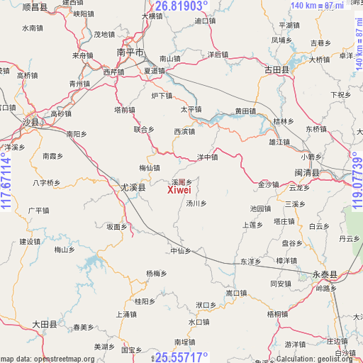
Xiwei GPS coordinates[2]
26° 11' 23.316" North, 118° 22' 27.336" East
| Map corner | latitude | longitude |
|---|---|---|
| Upper-left | 26.81903°, | 117.67114° |
| Center: | 26.18981°, | 118.37426° |
| Lower-right: | 25.55717°, | 119.07739° |
| Map W x H: | 140.3×140.3 km | = 87.2×87.2mi |
| max Lat: | 53.31946° ⇑81.6% North |
| Xiwei: | 26.18981° |
| min Lat: | ⇓18.4% South 18.22056° |
| min Long | Xiwei | max Long |
| 75.07348° | 118.37426° | 134.28917° |
| W 72.4%⇐ | ⇒27.6% E |
Elevation
Elevation of Xiwei is 203 m = 666 ft, and this is 281.8 m = 925 ft below average elevation for this country.
| Max E: |
5622 m = 18445 ft | 45.4% |
| Avg. | 484.8 m = 1591 ft | |
| Xiwei | 203 m = 666 ft | |
Min E: |
-3 m = -10 ft | 54.6% |
See also: China elevation on elevation.city.
Geographical zone
Xiwei is located in North temperate zone (between Tropic of Cancer and the Arctic Circle). Distance of this Northern Tropic circle is 306.1 km =190.2 mi to South.| Distance of | km | miles | from Xiwei |
|---|---|---|---|
| North Pole | 7095 | 4408.6 | to North |
| Arctic Circle | 4489.1 | 2789.4 | to North |
| Tropic Cancer | 306.1 | 190.2 | to South |
| Equator | 2912 | 1809.4 | to South |


Nearby cities:
15 places around Xiwei: (largest is in red/bold)
• Banmian
30.7 km =19.1 mi,  235°
235°
• Chiyuan
32 km =19.9 mi,  108°
108°
• Houjia
24.3 km =15.1 mi,  134°
134°
• Jiatou
28.9 km =18 mi, 126°
• Meixian
13.8 km =8.6 mi,  294°
294°
• Tadou
24.8 km =15.4 mi,  324°
324°
• Taiping
28.8 km =17.9 mi,  8°
8°
• Taixi
16 km =9.9 mi,  232°
232°
• Tangchuan
9.8 km =6.1 mi,  148°
148°
• Xibin
19.8 km =12.3 mi,  0°
0°
• Xicheng
23.4 km =14.5 mi,  262°
262°
• Youxi Chengguanzhen
19.6 km =12.2 mi, 264°
• Youxikou
24.2 km =15 mi,  16°
16°
• Zhanghuban
24.5 km =15.2 mi,  26°
26°
• Zhongxian
26.6 km =16.5 mi,  180°
180°
Sources, notices
• [Note1] Compared only with cities in China existing in our database
• [Src1] Map data: © OpenStreetMap contributors (CC-BY-SA)
• [Src2] Other city data from geonames.org with taken over terms of usage.
• [Src3] Geographical zone / Annual Mean Temperature by Robert A. Rohde @ Wikipedia
