Zhanghuban geodata
Zhanghuban (Fujian) is a seat of a fourth-order administrative division; located in China in Asia/Shanghai (GMT+8) time zone. In our database, there are 1268 cities with bigger population. Compared to other cities in China, 80.9% of cities are located further ↑North; 73.1% of cities are located further ←West and 60.9% of cities have higher elevation than Zhanghuban. Note1


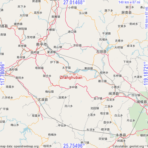
Zhanghuban GPS coordinates[2]
26° 23' 11.544" North, 118° 29' 2.688" East
| Map corner | latitude | longitude |
|---|---|---|
| Upper-left | 27.01468°, | 117.78096° |
| Center: | 26.38654°, | 118.48408° |
| Lower-right: | 25.75496°, | 119.18721° |
| Map W x H: | 140.1×140.1 km | = 87.1×87.1mi |
| max Lat: | 53.31946° ⇑80.9% North |
| Zhanghuban: | 26.38654° |
| min Lat: | ⇓19.1% South 18.22056° |
| min Long | Zhanghuban | max Long |
| 75.07348° | 118.48408° | 134.28917° |
| W 73.1%⇐ | ⇒26.9% E |
Elevation
Elevation of Zhanghuban is 93 m = 305 ft, and this is 391.8 m = 1285 ft below average elevation for this country.
| Max E: |
5622 m = 18445 ft | 60.9% |
| Avg. | 484.8 m = 1591 ft | |
| Zhanghuban | 93 m = 305 ft | |
Min E: |
-3 m = -10 ft | 39.1% |
See also: China elevation on elevation.city.
Geographical zone
Zhanghuban is located in North temperate zone (between Tropic of Cancer and the Arctic Circle). Distance of this Northern Tropic circle is 328 km =203.8 mi to South.| Distance of | km | miles | from Zhanghuban |
|---|---|---|---|
| North Pole | 7073.2 | 4395.1 | to North |
| Arctic Circle | 4467.3 | 2775.9 | to North |
| Tropic Cancer | 328 | 203.8 | to South |
| Equator | 2933.9 | 1823 | to South |


Nearby cities:
15 places around Zhanghuban: (largest is in red/bold)
• Chimen
18 km =11.2 mi,  348°
348°
• Huangtian
15.1 km =9.4 mi,  67°
67°
• Jielin
28.4 km =17.6 mi,  86°
86°
• Luxia
22 km =13.7 mi,  301°
301°
• Meixian
28.6 km =17.8 mi,  235°
235°
• Nanshan
30.4 km =18.9 mi,  328°
328°
• Shuikou
24.5 km =15.2 mi, 90°
• Tadou
25.4 km =15.8 mi,  266°
266°
• Taiping
9.3 km =5.8 mi,  315°
315°
• Xiadao
29.9 km =18.6 mi,  314°
314°
• Xibin
11.1 km =6.9 mi,  259°
259°
• Xiongjiang
26.4 km =16.4 mi,  102°
102°
• Xiwei
24.5 km =15.2 mi,  206°
206°
• Yanghou
28.4 km =17.6 mi,  4°
4°
• Youxikou
4.2 km =2.6 mi,  287°
287°
Sources, notices
• [Note1] Compared only with cities in China existing in our database
• [Src1] Map data: © OpenStreetMap contributors (CC-BY-SA)
• [Src2] Other city data from geonames.org with taken over terms of usage.
• [Src3] Geographical zone / Annual Mean Temperature by Robert A. Rohde @ Wikipedia
