Xinshao geodata
Xinshao (Guangdong) is a seat of a fourth-order administrative division; located in China in Asia/Shanghai (GMT+8) time zone. In our database, there are 1268 cities with bigger population. Compared to other cities in China, 87.1% of cities are located further ↑North; 53.6% of cities are located further →East and 69.5% of cities have higher elevation than Xinshao. Note1


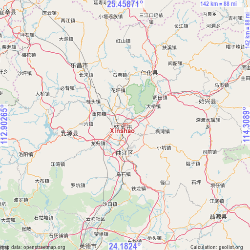
Xinshao GPS coordinates[2]
24° 49' 19.92" North, 113° 36' 20.772" East
| Map corner | latitude | longitude |
|---|---|---|
| Upper-left | 25.45871°, | 112.90265° |
| Center: | 24.8222°, | 113.60577° |
| Lower-right: | 24.1824°, | 114.3089° |
| Map W x H: | 141.9×141.9 km | = 88.2×88.2mi |
| max Lat: | 53.31946° ⇑87.1% North |
| Xinshao: | 24.8222° |
| min Lat: | ⇓12.9% South 18.22056° |
| min Long | Xinshao | max Long |
| 75.07348° | 113.60577° | 134.28917° |
| W 46.4%⇐ | ⇒53.6% E |
Elevation
Elevation of Xinshao is 54 m = 177 ft, and this is 430.8 m = 1413 ft below average elevation for this country.
| Max E: |
5622 m = 18445 ft | 69.5% |
| Avg. | 484.8 m = 1591 ft | |
| Xinshao | 54 m = 177 ft | |
Min E: |
-3 m = -10 ft | 30.5% |
See also: China elevation on elevation.city.
Geographical zone
Xinshao is located in North temperate zone (between Tropic of Cancer and the Arctic Circle). Distance of this Northern Tropic circle is 154.1 km =95.8 mi to South.| Distance of | km | miles | from Xinshao |
|---|---|---|---|
| North Pole | 7247.1 | 4503.1 | to North |
| Arctic Circle | 4641.2 | 2883.9 | to North |
| Tropic Cancer | 154.1 | 95.8 | to South |
| Equator | 2760 | 1715 | to South |


Nearby cities:
15 places around Xinshao: (largest is in red/bold)
• Baitu
18 km =11.2 mi,  210°
210°
• Daqiao
18 km =11.2 mi,  56°
56°
• Datang
10.3 km =6.4 mi,  121°
121°
• Fengwan
20.6 km =12.8 mi,  96°
96°
• Huaping
21.5 km =13.4 mi,  351°
351°
• Leyuan
7.8 km =4.8 mi,  198°
198°
• Lishi
12 km =7.5 mi,  317°
317°
• Longgui
18.6 km =11.6 mi,  238°
238°
• Maba
15.4 km =9.6 mi,  182°
182°
• Shaoguan
3.3 km =2.1 mi,  222°
222°
• Shiliting
5 km =3.1 mi,  304°
304°
• Xihe
5 km =3.1 mi, 244°
• Xilian
9.9 km =6.2 mi,  226°
226°
• Yiliu
20.3 km =12.6 mi,  274°
274°
• Zhongyang
16.3 km =10.1 mi,  294°
294°
Sources, notices
• [Note1] Compared only with cities in China existing in our database
• [Src1] Map data: © OpenStreetMap contributors (CC-BY-SA)
• [Src2] Other city data from geonames.org with taken over terms of usage.
• [Src3] Geographical zone / Annual Mean Temperature by Robert A. Rohde @ Wikipedia
