Luoqiao geodata
Luoqiao (Fujian) is a populated place; located in China in Asia/Shanghai (GMT+8) time zone. With population of 1,030 people, there are 1167 cities with bigger population in this country. Compared to other cities in China, 80.6% of cities are located further ↑North; 76% of cities are located further ←West and 82.6% of cities have lower elevation than Luoqiao. Note1


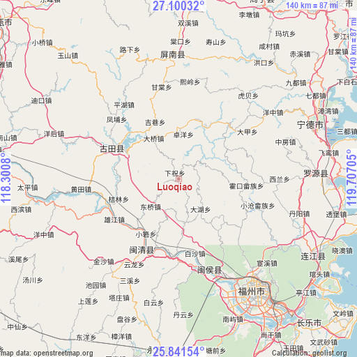
Luoqiao GPS coordinates[2]
26° 28' 21.54" North, 119° 0' 14.112" East
| Map corner | latitude | longitude |
|---|---|---|
| Upper-left | 27.10032°, | 118.3008° |
| Center: | 26.47265°, | 119.00392° |
| Lower-right: | 25.84154°, | 119.70705° |
| Map W x H: | 140×140 km | = 87×87mi |
| max Lat: | 53.31946° ⇑80.6% North |
| Luoqiao: | 26.47265° |
| min Lat: | ⇓19.4% South 18.22056° |
| min Long | Luoqiao | max Long |
| 75.07348° | 119.00392° | 134.28917° |
| W 76%⇐ | ⇒24% E |
Elevation
Elevation of Luoqiao is 826 m = 2710 ft, and this is 341.2 m = 1119 ft above average elevation for this country.
| Max E: |
5622 m = 18445 ft | 17.4% |
| Luoqiao | 826 m 2710 ft | |
| Avg. | 484.8 m = 1591 ft | |
Min E: |
-3 m = -10 ft | 82.6% |
See also: China elevation on elevation.city.
Geographical zone
Luoqiao is located in North temperate zone (between Tropic of Cancer and the Arctic Circle). Distance of this Northern Tropic circle is 337.6 km =209.8 mi to South.| Distance of | km | miles | from Luoqiao |
|---|---|---|---|
| North Pole | 7063.6 | 4389.1 | to North |
| Arctic Circle | 4457.7 | 2769.9 | to North |
| Tropic Cancer | 337.6 | 209.8 | to South |
| Equator | 2943.5 | 1829 | to South |


Nearby cities:
15 places around Luoqiao: (largest is in red/bold)
• Dahu
14.7 km =9.1 mi,  143°
143°
• Daping
17.4 km =10.8 mi,  171°
171°
• Daqiao
18.6 km =11.6 mi,  328°
328°
• Dongqiao
16 km =9.9 mi,  224°
224°
• Hengyang
14.1 km =8.8 mi, 326°
• Hetang
23.7 km =14.7 mi,  26°
26°
• Huokou
26.9 km =16.7 mi,  95°
95°
• Jielin
24.7 km =15.3 mi,  251°
251°
• Jixiang
24 km =14.9 mi,  337°
337°
• Panyang
19.2 km =11.9 mi,  296°
296°
• Tingping
7.2 km =4.5 mi,  42°
42°
• Xiaoruo
25.3 km =15.7 mi,  211°
211°
• Xiazhu
2.7 km =1.7 mi, 328°
• Yangli
12.9 km =8 mi,  201°
201°
• Zhuoyang
17.6 km =10.9 mi,  5°
5°
Sources, notices
• [Note1] Compared only with cities in China existing in our database
• [Src1] Map data: © OpenStreetMap contributors (CC-BY-SA)
• [Src2] Other city data from geonames.org with taken over terms of usage.
• [Src3] Geographical zone / Annual Mean Temperature by Robert A. Rohde @ Wikipedia
