Hengyang geodata
Hengyang (Fujian) is a populated place; located in China in Asia/Shanghai (GMT+8) time zone. With population of 630 people, there are 1244 cities with bigger population in this country. Compared to other cities in China, 80.2% of cities are located further ↑North; 75.7% of cities are located further ←West and 75.1% of cities have lower elevation than Hengyang. Note1


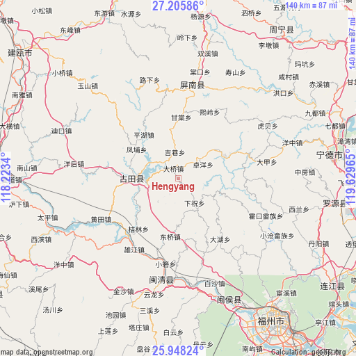
Hengyang GPS coordinates[2]
26° 34' 43.608" North, 118° 55' 35.472" East
| Map corner | latitude | longitude |
|---|---|---|
| Upper-left | 27.20586°, | 118.2234° |
| Center: | 26.57878°, | 118.92652° |
| Lower-right: | 25.94824°, | 119.62965° |
| Map W x H: | 139.8×139.8 km | = 86.9×86.9mi |
| max Lat: | 53.31946° ⇑80.2% North |
| Hengyang: | 26.57878° |
| min Lat: | ⇓19.8% South 18.22056° |
| min Long | Hengyang | max Long |
| 75.07348° | 118.92652° | 134.28917° |
| W 75.7%⇐ | ⇒24.3% E |
Elevation
Elevation of Hengyang is 525 m = 1722 ft, and this is 40.2 m = 132 ft above average elevation for this country.
| Max E: |
5622 m = 18445 ft | 24.9% |
| Hengyang | 525 m 1722 ft | |
| Avg. | 484.8 m = 1591 ft | |
Min E: |
-3 m = -10 ft | 75.1% |
See also: China elevation on elevation.city.
Geographical zone
Hengyang is located in North temperate zone (between Tropic of Cancer and the Arctic Circle). Distance of this Northern Tropic circle is 349.4 km =217.1 mi to South.| Distance of | km | miles | from Hengyang |
|---|---|---|---|
| North Pole | 7051.8 | 4381.8 | to North |
| Arctic Circle | 4445.9 | 2762.6 | to North |
| Tropic Cancer | 349.4 | 217.1 | to South |
| Equator | 2955.3 | 1836.3 | to South |


Nearby cities:
15 places around Hengyang: (largest is in red/bold)
• Chengdong
18.7 km =11.6 mi,  269°
269°
• Daqiao
4.5 km =2.8 mi,  333°
333°
• Dongqiao
23.4 km =14.5 mi,  188°
188°
• Fengpu
20.2 km =12.6 mi,  304°
304°
• Gantang
24.4 km =15.2 mi,  2°
2°
• Hetang
20.5 km =12.7 mi,  62°
62°
• Jixiang
10.5 km =6.5 mi,  352°
352°
• Luoqiao
14.1 km =8.8 mi,  146°
146°
• Panyang
10 km =6.2 mi,  251°
251°
• Pinghu
22.1 km =13.7 mi,  322°
322°
• Songji
18.5 km =11.5 mi, 269°
• Tingping
14.2 km =8.8 mi,  117°
117°
• Xiazhu
11.4 km =7.1 mi, 146°
• Yangli
24 km =14.9 mi,  173°
173°
• Zhuoyang
11 km =6.8 mi, 58°
Sources, notices
• [Note1] Compared only with cities in China existing in our database
• [Src1] Map data: © OpenStreetMap contributors (CC-BY-SA)
• [Src2] Other city data from geonames.org with taken over terms of usage.
• [Src3] Geographical zone / Annual Mean Temperature by Robert A. Rohde @ Wikipedia
