Daping geodata
Daping (Fujian) is a populated place; located in China in Asia/Shanghai (GMT+8) time zone. With population of 850 people, there are 1206 cities with bigger population in this country. Compared to other cities in China, 81.1% of cities are located further ↑North; 76.2% of cities are located further ←West and 75.3% of cities have lower elevation than Daping. Note1


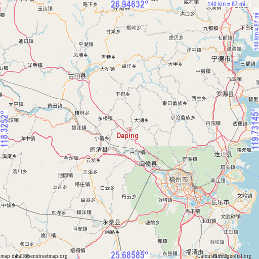
Daping GPS coordinates[2]
26° 19' 4.08" North, 119° 1' 41.952" East
| Map corner | latitude | longitude |
|---|---|---|
| Upper-left | 26.94632°, | 118.3252° |
| Center: | 26.3178°, | 119.02832° |
| Lower-right: | 25.68585°, | 119.73145° |
| Map W x H: | 140.2×140.2 km | = 87.1×87.1mi |
| max Lat: | 53.31946° ⇑81.1% North |
| Daping: | 26.3178° |
| min Lat: | ⇓18.9% South 18.22056° |
| min Long | Daping | max Long |
| 75.07348° | 119.02832° | 134.28917° |
| W 76.2%⇐ | ⇒23.8% E |
Elevation
Elevation of Daping is 529 m = 1736 ft, and this is 44.2 m = 145 ft above average elevation for this country.
| Max E: |
5622 m = 18445 ft | 24.7% |
| Daping | 529 m 1736 ft | |
| Avg. | 484.8 m = 1591 ft | |
Min E: |
-3 m = -10 ft | 75.3% |
See also: China elevation on elevation.city.
Geographical zone
Daping is located in North temperate zone (between Tropic of Cancer and the Arctic Circle). Distance of this Northern Tropic circle is 320.3 km =199 mi to South.| Distance of | km | miles | from Daping |
|---|---|---|---|
| North Pole | 7080.8 | 4399.8 | to North |
| Arctic Circle | 4474.9 | 2780.6 | to North |
| Tropic Cancer | 320.3 | 199 | to South |
| Equator | 2926.3 | 1818.3 | to South |


Nearby cities:
15 places around Daping: (largest is in red/bold)
• Baisha
12.7 km =7.9 mi,  161°
161°
• Dahu
8.2 km =5.1 mi,  49°
49°
• Dongqiao
14.9 km =9.3 mi,  293°
293°
• Hongwei
16.8 km =10.4 mi,  190°
190°
• Luoqiao
17.4 km =10.8 mi,  351°
351°
• Meicheng
20.2 km =12.6 mi,  235°
235°
• Meipu
17.8 km =11.1 mi,  228°
228°
• Meixi
19.2 km =11.9 mi, 230°
• Rong’an
23.4 km =14.5 mi, 156°
• Shoushan
22.3 km =13.9 mi,  111°
111°
• Tingping
22.7 km =14.1 mi,  6°
6°
• Xiaoruo
16.2 km =10.1 mi,  253°
253°
• Xiazhu
19.9 km =12.4 mi, 348°
• Yangli
8.9 km =5.5 mi,  305°
305°
• Zhuqi
20.2 km =12.6 mi, 158°
Sources, notices
• [Note1] Compared only with cities in China existing in our database
• [Src1] Map data: © OpenStreetMap contributors (CC-BY-SA)
• [Src2] Other city data from geonames.org with taken over terms of usage.
• [Src3] Geographical zone / Annual Mean Temperature by Robert A. Rohde @ Wikipedia
