Xiazhu geodata
Xiazhu (Fujian) is a seat of a fourth-order administrative division; located in China in Asia/Shanghai (GMT+8) time zone. In our database, there are 1268 cities with bigger population. Compared to other cities in China, 80.5% of cities are located further ↑North; 76% of cities are located further ←West and 81.4% of cities have lower elevation than Xiazhu. Note1


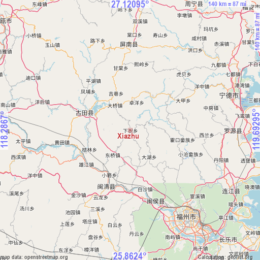
Xiazhu GPS coordinates[2]
26° 29' 36.24" North, 118° 59' 23.352" East
| Map corner | latitude | longitude |
|---|---|---|
| Upper-left | 27.12095°, | 118.2867° |
| Center: | 26.4934°, | 118.98982° |
| Lower-right: | 25.8624°, | 119.69295° |
| Map W x H: | 139.9×139.9 km | = 86.9×86.9mi |
| max Lat: | 53.31946° ⇑80.5% North |
| Xiazhu: | 26.4934° |
| min Lat: | ⇓19.5% South 18.22056° |
| min Long | Xiazhu | max Long |
| 75.07348° | 118.98982° | 134.28917° |
| W 76%⇐ | ⇒24% E |
Elevation
Elevation of Xiazhu is 761 m = 2497 ft, and this is 276.2 m = 906 ft above average elevation for this country.
| Max E: |
5622 m = 18445 ft | 18.6% |
| Xiazhu | 761 m 2497 ft | |
| Avg. | 484.8 m = 1591 ft | |
Min E: |
-3 m = -10 ft | 81.4% |
See also: China elevation on elevation.city.
Geographical zone
Xiazhu is located in North temperate zone (between Tropic of Cancer and the Arctic Circle). Distance of this Northern Tropic circle is 339.9 km =211.2 mi to South.| Distance of | km | miles | from Xiazhu |
|---|---|---|---|
| North Pole | 7061.3 | 4387.7 | to North |
| Arctic Circle | 4455.4 | 2768.5 | to North |
| Tropic Cancer | 339.9 | 211.2 | to South |
| Equator | 2945.8 | 1830.4 | to South |


Nearby cities:
15 places around Xiazhu: (largest is in red/bold)
• Dahu
17.4 km =10.8 mi,  144°
144°
• Daping
19.9 km =12.4 mi,  168°
168°
• Daqiao
15.9 km =9.9 mi,  328°
328°
• Dongqiao
16.8 km =10.4 mi,  215°
215°
• Hengyang
11.4 km =7.1 mi, 326°
• Hetang
22.3 km =13.9 mi,  32°
32°
• Jielin
24.3 km =15.1 mi,  245°
245°
• Jixiang
21.4 km =13.3 mi,  338°
338°
• Luoqiao
2.7 km =1.7 mi,  148°
148°
• Panyang
17 km =10.6 mi,  291°
291°
• Songji
26.5 km =16.5 mi, 290°
• Tingping
7 km =4.3 mi,  64°
64°
• Xiaoruo
26.7 km =16.6 mi,  205°
205°
• Yangli
14.7 km =9.1 mi,  193°
193°
• Zhuoyang
15.5 km =9.6 mi,  11°
11°
Sources, notices
• [Note1] Compared only with cities in China existing in our database
• [Src1] Map data: © OpenStreetMap contributors (CC-BY-SA)
• [Src2] Other city data from geonames.org with taken over terms of usage.
• [Src3] Geographical zone / Annual Mean Temperature by Robert A. Rohde @ Wikipedia
