Panyang geodata
Panyang (Fujian) is a seat of a fourth-order administrative division; located in China in Asia/Shanghai (GMT+8) time zone. With population of 880 people, there are 1202 cities with bigger population in this country. Compared to other cities in China, 80.3% of cities are located further ↑North; 75.2% of cities are located further ←West and 79.6% of cities have lower elevation than Panyang. Note1


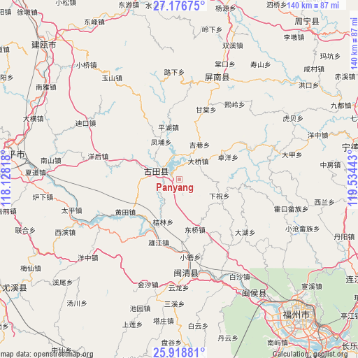
Panyang GPS coordinates[2]
26° 32' 58.2" North, 118° 49' 52.68" East
| Map corner | latitude | longitude |
|---|---|---|
| Upper-left | 27.17675°, | 118.12818° |
| Center: | 26.5495°, | 118.8313° |
| Lower-right: | 25.91881°, | 119.53443° |
| Map W x H: | 139.9×139.9 km | = 86.9×86.9mi |
| max Lat: | 53.31946° ⇑80.3% North |
| Panyang: | 26.5495° |
| min Lat: | ⇓19.7% South 18.22056° |
| min Long | Panyang | max Long |
| 75.07348° | 118.8313° | 134.28917° |
| W 75.2%⇐ | ⇒24.8% E |
Elevation
Elevation of Panyang is 678 m = 2224 ft, and this is 193.2 m = 634 ft above average elevation for this country.
| Max E: |
5622 m = 18445 ft | 20.4% |
| Panyang | 678 m 2224 ft | |
| Avg. | 484.8 m = 1591 ft | |
Min E: |
-3 m = -10 ft | 79.6% |
See also: China elevation on elevation.city.
Geographical zone
Panyang is located in North temperate zone (between Tropic of Cancer and the Arctic Circle). Distance of this Northern Tropic circle is 346.1 km =215.1 mi to South.| Distance of | km | miles | from Panyang |
|---|---|---|---|
| North Pole | 7055 | 4383.8 | to North |
| Arctic Circle | 4449.1 | 2764.5 | to North |
| Tropic Cancer | 346.1 | 215.1 | to South |
| Equator | 2952 | 1834.3 | to South |


Nearby cities:
15 places around Panyang: (largest is in red/bold)
• Chengdong
9.8 km =6.1 mi,  289°
289°
• Daqiao
10.4 km =6.5 mi,  45°
45°
• Dongqiao
20.7 km =12.9 mi,  163°
163°
• Fengpu
16.4 km =10.2 mi,  334°
334°
• Hengyang
10 km =6.2 mi,  71°
71°
• Jielin
17.6 km =10.9 mi,  200°
200°
• Jixiang
15.9 km =9.9 mi,  30°
30°
• Luoqiao
19.2 km =11.9 mi,  116°
116°
• Pinghu
21.2 km =13.2 mi,  349°
349°
• Shuangzhu
20.6 km =12.8 mi,  296°
296°
• Shuikou
21 km =13 mi,  208°
208°
• Songji
9.5 km =5.9 mi, 288°
• Tingping
22.3 km =13.9 mi,  98°
98°
• Xiazhu
17 km =10.6 mi,  111°
111°
• Zhuoyang
20.9 km =13 mi,  64°
64°
Sources, notices
• [Note1] Compared only with cities in China existing in our database
• [Src1] Map data: © OpenStreetMap contributors (CC-BY-SA)
• [Src2] Other city data from geonames.org with taken over terms of usage.
• [Src3] Geographical zone / Annual Mean Temperature by Robert A. Rohde @ Wikipedia
