Shangmei geodata
Shangmei (Hunan) is a seat of a third-order administrative division; located in China in Asia/Shanghai (GMT+8) time zone. With population of 75,233 people, there are 568 cities with bigger population in this country. Compared to other cities in China, 75.5% of cities are located further ↑North; 65.9% of cities are located further →East and 51.7% of cities have lower elevation than Shangmei. Note1


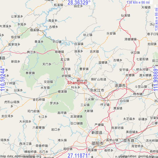
Shangmei GPS coordinates[2]
27° 44' 34.008" North, 111° 17' 44.016" East
| Map corner | latitude | longitude |
|---|---|---|
| Upper-left | 28.36329°, | 110.59244° |
| Center: | 27.74278°, | 111.29556° |
| Lower-right: | 27.11871°, | 111.99869° |
| Map W x H: | 138.4×138.4 km | = 86×86mi |
| max Lat: | 53.31946° ⇑75.5% North |
| Shangmei: | 27.74278° |
| min Lat: | ⇓24.5% South 18.22056° |
| min Long | Shangmei | max Long |
| 75.07348° | 111.29556° | 134.28917° |
| W 34.1%⇐ | ⇒65.9% E |
Elevation
Elevation of Shangmei is 179 m = 587 ft, and this is 305.8 m = 1003 ft below average elevation for this country.
| Max E: |
5622 m = 18445 ft | 48.3% |
| Avg. | 484.8 m = 1591 ft | |
| Shangmei | 179 m = 587 ft | |
Min E: |
-3 m = -10 ft | 51.7% |
See also: Shangmei elevation on elevation.city.
Geographical zone
Shangmei is located in North temperate zone (between Tropic of Cancer and the Arctic Circle). Distance of this Northern Tropic circle is 478.8 km =297.5 mi to South.| Distance of | km | miles | from Shangmei |
|---|---|---|---|
| North Pole | 6922.4 | 4301.4 | to North |
| Arctic Circle | 4316.5 | 2682.1 | to North |
| Tropic Cancer | 478.8 | 297.5 | to South |
| Equator | 3084.7 | 1916.7 | to South |


Nearby cities:
15 places around Shangmei: (largest is in red/bold)
• Baixi
30 km =18.6 mi,  2°
2°
• Gaoping
32.9 km =20.4 mi,  207°
207°
• Huangjinjing
43.5 km =27 mi,  246°
246°
• Jinshiqiao
39.5 km =24.5 mi,  243°
243°
• Langtang
32.6 km =20.3 mi,  333°
333°
• Lengshuijiang
14.5 km =9 mi,  114°
114°
• Lianyuan
36.8 km =22.9 mi,  99°
99°
• Luohong
30.1 km =18.7 mi,  226°
226°
• Qijiang
45.5 km =28.3 mi,  224°
224°
• Shanxi
46.4 km =28.8 mi,  313°
313°
• Shuiche
29.8 km =18.5 mi,  257°
257°
• Xixi
34.1 km =21.2 mi, 260°
• Yanggu’ao
44.8 km =27.8 mi, 230°
• Yatian
32.4 km =20.1 mi, 238°
• Zhenshang
40.6 km =25.2 mi,  12°
12°
Sources, notices
• [Note1] Compared only with cities in China existing in our database
• [Src1] Map data: © OpenStreetMap contributors (CC-BY-SA)
• [Src2] Other city data from geonames.org with taken over terms of usage.
• [Src3] Geographical zone / Annual Mean Temperature by Robert A. Rohde @ Wikipedia
