Luocheng geodata
Luocheng (Sichuan) is a populated place; located in China in Asia/Shanghai (GMT+8) time zone. With population of 73,581 people, there are 583 cities with bigger population in this country. Compared to other cities in China, 60.9% of cities are located further ↑North; 90.3% of cities are located further →East and 72.8% of cities have lower elevation than Luocheng. Note1


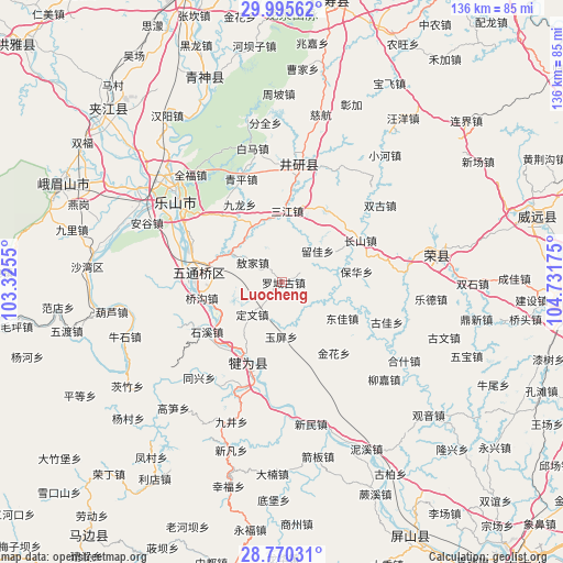
Luocheng GPS coordinates[2]
29° 23' 5.316" North, 104° 1' 43.032" East
| Map corner | latitude | longitude |
|---|---|---|
| Upper-left | 29.99562°, | 103.3255° |
| Center: | 29.38481°, | 104.02862° |
| Lower-right: | 28.77031°, | 104.73175° |
| Map W x H: | 136.2×136.2 km | = 84.6×84.6mi |
| max Lat: | 53.31946° ⇑60.9% North |
| Luocheng: | 29.38481° |
| min Lat: | ⇓39.1% South 18.22056° |
| min Long | Luocheng | max Long |
| 75.07348° | 104.02862° | 134.28917° |
| W 9.7%⇐ | ⇒90.3% E |
Elevation
Elevation of Luocheng is 471 m = 1545 ft, and this is 13.8 m = 45 ft below average elevation for this country.
| Max E: |
5622 m = 18445 ft | 27.2% |
| Avg. | 484.8 m = 1591 ft | |
| Luocheng | 471 m = 1545 ft | |
Min E: |
-3 m = -10 ft | 72.8% |
See also: Luocheng elevation on elevation.city.
Geographical zone
Luocheng is located in North temperate zone (between Tropic of Cancer and the Arctic Circle). Distance of this Northern Tropic circle is 661.4 km =411 mi to South.| Distance of | km | miles | from Luocheng |
|---|---|---|---|
| North Pole | 6739.8 | 4187.9 | to North |
| Arctic Circle | 4133.9 | 2568.7 | to North |
| Tropic Cancer | 661.4 | 411 | to South |
| Equator | 3267.3 | 2030.2 | to South |


Nearby cities:
15 places around Luocheng: (largest is in red/bold)
• Gongjing
66.3 km =41.2 mi,  93°
93°
• Leshan
32.3 km =20.1 mi,  307°
307°
• Muxi
48.9 km =30.4 mi,  194°
194°
• Nan’an
68.1 km =42.3 mi, 310°
• Shaping
75.9 km =47.2 mi,  256°
256°
• Shawan
47.1 km =29.3 mi,  273°
273°
• Suishan
58.1 km =36.1 mi,  295°
295°
• Wenlin
69 km =42.9 mi,  8°
8°
• Xinfa
67.8 km =42.1 mi,  155°
155°
• Xuyang
38.8 km =24.1 mi,  77°
77°
• Yancheng
29.8 km =18.5 mi, 7°
• Yancheng
59.9 km =37.2 mi, 311°
• Yanling
63.3 km =39.3 mi, 75°
• Yujin
21.1 km =13.1 mi,  202°
202°
• Zigong
72.7 km =45.2 mi, 93°
Sources, notices
• [Note1] Compared only with cities in China existing in our database
• [Src1] Map data: © OpenStreetMap contributors (CC-BY-SA)
• [Src2] Other city data from geonames.org with taken over terms of usage.
• [Src3] Geographical zone / Annual Mean Temperature by Robert A. Rohde @ Wikipedia
