Wenlin geodata
Wenlin (Sichuan) is a seat of a third-order administrative division; located in China in Asia/Shanghai (GMT+8) time zone. In our database, there are 1268 cities with bigger population. Compared to other cities in China, 54% of cities are located further ↑North; 90.1% of cities are located further →East and 70.8% of cities have lower elevation than Wenlin. Note1


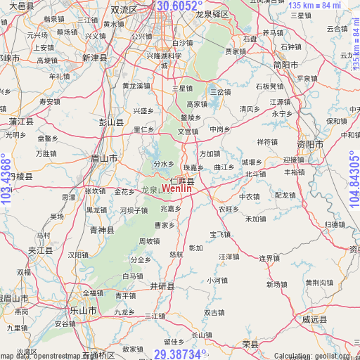
Wenlin GPS coordinates[2]
29° 59' 53.304" North, 104° 8' 23.712" East
| Map corner | latitude | longitude |
|---|---|---|
| Upper-left | 30.6052°, | 103.4368° |
| Center: | 29.99814°, | 104.13992° |
| Lower-right: | 29.38734°, | 104.84305° |
| Map W x H: | 135.4×135.4 km | = 84.1×84.1mi |
| max Lat: | 53.31946° ⇑54% North |
| Wenlin: | 29.99814° |
| min Lat: | ⇓46% South 18.22056° |
| min Long | Wenlin | max Long |
| 75.07348° | 104.13992° | 134.28917° |
| W 9.9%⇐ | ⇒90.1% E |
Elevation
Elevation of Wenlin is 426 m = 1398 ft, and this is 58.8 m = 193 ft below average elevation for this country.
| Max E: |
5622 m = 18445 ft | 29.2% |
| Avg. | 484.8 m = 1591 ft | |
| Wenlin | 426 m = 1398 ft | |
Min E: |
-3 m = -10 ft | 70.8% |
See also: China elevation on elevation.city.
Geographical zone
Wenlin is located in North temperate zone (between Tropic of Cancer and the Arctic Circle). Distance of this Northern Tropic circle is 729.6 km =453.4 mi to South.| Distance of | km | miles | from Wenlin |
|---|---|---|---|
| North Pole | 6671.6 | 4145.5 | to North |
| Arctic Circle | 4065.7 | 2526.3 | to North |
| Tropic Cancer | 729.6 | 453.4 | to South |
| Equator | 3335.5 | 2072.6 | to South |


Nearby cities:
15 places around Wenlin: (largest is in red/bold)
• Chengdu
74.7 km =46.4 mi,  354°
354°
• Chonglong
72.8 km =45.2 mi,  109°
109°
• Dongsheng
67.4 km =41.9 mi,  341°
341°
• Jiancheng
58.8 km =36.5 mi,  41°
41°
• Leshan
60.5 km =37.6 mi,  216°
216°
• Longquan
63.8 km =39.6 mi,  11°
11°
• Luocheng
69 km =42.9 mi,  188°
188°
• Nan’an
66.7 km =41.4 mi,  249°
249°
• Suishan
76.5 km =47.5 mi,  235°
235°
• Wujin
55.7 km =34.6 mi,  325°
325°
• Xuyang
65.7 km =40.8 mi,  155°
155°
• Yancheng
39.3 km =24.4 mi, 190°
• Yancheng
62.1 km =38.6 mi, 242°
• Yanjiang
50.8 km =31.6 mi,  74°
74°
• Yanling
72.3 km =44.9 mi,  135°
135°
Sources, notices
• [Note1] Compared only with cities in China existing in our database
• [Src1] Map data: © OpenStreetMap contributors (CC-BY-SA)
• [Src2] Other city data from geonames.org with taken over terms of usage.
• [Src3] Geographical zone / Annual Mean Temperature by Robert A. Rohde @ Wikipedia
