Nan’an geodata
Nan’an (Sichuan) is a seat of a fourth-order administrative division; located in China in Asia/Shanghai (GMT+8) time zone. In our database, there are 1268 cities with bigger population. Compared to other cities in China, 56.5% of cities are located further ↑North; 90.9% of cities are located further →East and 70.7% of cities have lower elevation than Nan’an. Note1


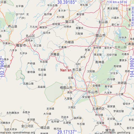
Nan’an GPS coordinates[2]
29° 47' 0.492" North, 103° 29' 37.644" East
| Map corner | latitude | longitude |
|---|---|---|
| Upper-left | 30.39185°, | 102.79067° |
| Center: | 29.78347°, | 103.49379° |
| Lower-right: | 29.17137°, | 104.19692° |
| Map W x H: | 135.7×135.7 km | = 84.3×84.3mi |
| max Lat: | 53.31946° ⇑56.5% North |
| Nan’an: | 29.78347° |
| min Lat: | ⇓43.5% South 18.22056° |
| min Long | Nan’an | max Long |
| 75.07348° | 103.49379° | 134.28917° |
| W 9.1%⇐ | ⇒90.9% E |
Elevation
Elevation of Nan’an is 424 m = 1391 ft, and this is 60.8 m = 199 ft below average elevation for this country.
| Max E: |
5622 m = 18445 ft | 29.3% |
| Avg. | 484.8 m = 1591 ft | |
| Nan’an | 424 m = 1391 ft | |
Min E: |
-3 m = -10 ft | 70.7% |
See also: China elevation on elevation.city.
Geographical zone
Nan’an is located in North temperate zone (between Tropic of Cancer and the Arctic Circle). Distance of this Northern Tropic circle is 705.7 km =438.5 mi to South.| Distance of | km | miles | from Nan’an |
|---|---|---|---|
| North Pole | 6695.5 | 4160.4 | to North |
| Arctic Circle | 4089.6 | 2541.2 | to North |
| Tropic Cancer | 705.7 | 438.5 | to South |
| Equator | 3311.6 | 2057.7 | to South |


Nearby cities:
15 places around Nan’an: (largest is in red/bold)
• Hepingyizu
71.7 km =44.6 mi,  213°
213°
• Leshan
35.9 km =22.3 mi,  133°
133°
• Linqiong
70.4 km =43.7 mi,  357°
357°
• Luocheng
68.1 km =42.3 mi, 130°
• Muping
92.5 km =57.5 mi,  314°
314°
• Shaping
65.3 km =40.6 mi,  199°
199°
• Shawan
41.7 km =25.9 mi,  173°
173°
• Shirong
94.5 km =58.7 mi,  239°
239°
• Suishan
19.5 km =12.1 mi,  182°
182°
• Wenlin
66.7 km =41.4 mi,  69°
69°
• Wujin
76.3 km =47.4 mi,  23°
23°
• Yancheng
8.3 km =5.2 mi,  122°
122°
• Yancheng
57.3 km =35.6 mi,  104°
104°
• Yucheng
52.7 km =32.7 mi,  295°
295°
• Yujin
77.4 km =48.1 mi,  145°
145°
Sources, notices
• [Note1] Compared only with cities in China existing in our database
• [Src1] Map data: © OpenStreetMap contributors (CC-BY-SA)
• [Src2] Other city data from geonames.org with taken over terms of usage.
• [Src3] Geographical zone / Annual Mean Temperature by Robert A. Rohde @ Wikipedia
