Lu’an geodata
Lu’an (Anhui) is a seat of a second-order administrative division; located in China in Asia/Shanghai (GMT+8) time zone. In our database, there are 1268 cities with bigger population. Compared to other cities in China, 59.7% of cities are located further ↓South; 63.2% of cities are located further ←West and 64.9% of cities have higher elevation than Lu’an. Note1


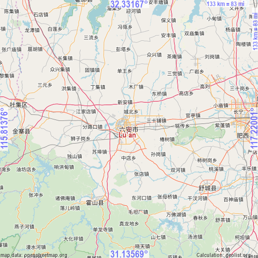
Lu’an GPS coordinates[2]
31° 44' 8.196" North, 116° 31' 0.768" East
| Map corner | latitude | longitude |
|---|---|---|
| Upper-left | 32.33167°, | 115.81376° |
| Center: | 31.73561°, | 116.51688° |
| Lower-right: | 31.13569°, | 117.22001° |
| Map W x H: | 133×133 km | = 82.6×82.6mi |
| max Lat: | 53.31946° ⇑40.3% North |
| Lu’an: | 31.73561° |
| min Lat: | ⇓59.7% South 18.22056° |
| min Long | Lu’an | max Long |
| 75.07348° | 116.51688° | 134.28917° |
| W 63.2%⇐ | ⇒36.8% E |
Elevation
Elevation of Lu’an is 73 m = 240 ft, and this is 411.8 m = 1351 ft below average elevation for this country.
| Max E: |
5622 m = 18445 ft | 64.9% |
| Avg. | 484.8 m = 1591 ft | |
| Lu’an | 73 m = 240 ft | |
Min E: |
-3 m = -10 ft | 35.1% |
See also: China elevation on elevation.city.
Geographical zone
Lu’an is located in North temperate zone (between Tropic of Cancer and the Arctic Circle). Distance of this Northern Tropic circle is 922.8 km =573.4 mi to South.| Distance of | km | miles | from Lu’an |
|---|---|---|---|
| North Pole | 6478.4 | 4025.5 | to North |
| Arctic Circle | 3872.5 | 2406.3 | to North |
| Tropic Cancer | 922.8 | 573.4 | to South |
| Equator | 3528.7 | 2192.6 | to South |


Nearby cities:
15 places around Lu’an: (largest is in red/bold)
• Dianbu
90.2 km =56 mi,  80°
80°
• Guoziyuan
96.4 km =59.9 mi,  242°
242°
• Gushi Chengguanzhen
92.9 km =57.7 mi,  300°
300°
• Hefei
73.6 km =45.7 mi, 78°
• Hengtanggang
21.6 km =13.4 mi,  184°
184°
• Huoqiu Chengguanzhen
72 km =44.7 mi,  343°
343°
• Lucheng
91.4 km =56.8 mi,  127°
127°
• Meishan
57.2 km =35.5 mi,  269°
269°
• Quedian
57 km =35.4 mi,  147°
147°
• Shangpai
60.9 km =37.8 mi,  88°
88°
• Shouchun
97.6 km =60.6 mi,  15°
15°
• Shucheng Chengguanzhen
50.4 km =31.3 mi, 125°
• Tongcheng
88.8 km =55.2 mi, 150°
• Wuyang
38.3 km =23.8 mi,  318°
318°
• Yaokou
83.2 km =51.7 mi, 17°
Sources, notices
• [Note1] Compared only with cities in China existing in our database
• [Src1] Map data: © OpenStreetMap contributors (CC-BY-SA)
• [Src2] Other city data from geonames.org with taken over terms of usage.
• [Src3] Geographical zone / Annual Mean Temperature by Robert A. Rohde @ Wikipedia
