Quedian geodata
Quedian (Anhui) is a seat of a fourth-order administrative division; located in China in Asia/Shanghai (GMT+8) time zone. In our database, there are 1268 cities with bigger population. Compared to other cities in China, 57.1% of cities are located further ↓South; 65.2% of cities are located further ←West and 70% of cities have higher elevation than Quedian. Note1


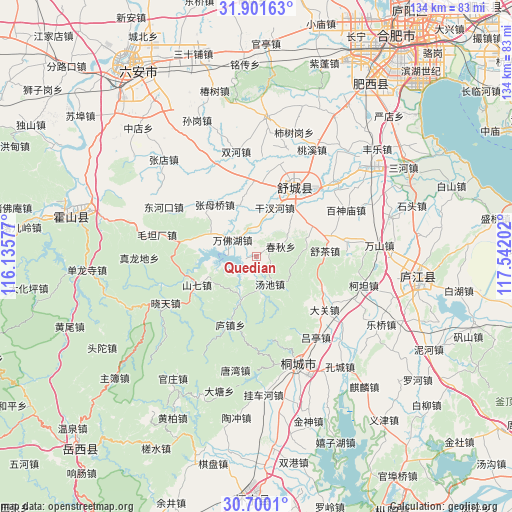
Quedian GPS coordinates[2]
31° 18' 10.008" North, 116° 50' 20.004" East
| Map corner | latitude | longitude |
|---|---|---|
| Upper-left | 31.90163°, | 116.13577° |
| Center: | 31.30278°, | 116.83889° |
| Lower-right: | 30.7001°, | 117.54202° |
| Map W x H: | 133.6×133.6 km | = 83×83mi |
| max Lat: | 53.31946° ⇑42.9% North |
| Quedian: | 31.30278° |
| min Lat: | ⇓57.1% South 18.22056° |
| min Long | Quedian | max Long |
| 75.07348° | 116.83889° | 134.28917° |
| W 65.2%⇐ | ⇒34.8% E |
Elevation
Elevation of Quedian is 52 m = 171 ft, and this is 432.8 m = 1420 ft below average elevation for this country.
| Max E: |
5622 m = 18445 ft | 70% |
| Avg. | 484.8 m = 1591 ft | |
| Quedian | 52 m = 171 ft | |
Min E: |
-3 m = -10 ft | 30% |
See also: China elevation on elevation.city.
Geographical zone
Quedian is located in North temperate zone (between Tropic of Cancer and the Arctic Circle). Distance of this Northern Tropic circle is 874.6 km =543.5 mi to South.| Distance of | km | miles | from Quedian |
|---|---|---|---|
| North Pole | 6526.5 | 4055.4 | to North |
| Arctic Circle | 3920.6 | 2436.1 | to North |
| Tropic Cancer | 874.6 | 543.5 | to South |
| Equator | 3480.5 | 2162.7 | to South |


Nearby cities:
15 places around Quedian: (largest is in red/bold)
• Anqing
90 km =55.9 mi,  167°
167°
• Chizhou
93.8 km =58.3 mi,  139°
139°
• Dianbu
86.4 km =53.7 mi,  42°
42°
• Gaohe
62.4 km =38.8 mi,  179°
179°
• Hefei
75.1 km =46.7 mi,  33°
33°
• Hengtanggang
41.7 km =25.9 mi,  309°
309°
• Lucheng
42.7 km =26.5 mi,  100°
100°
• Lu’an
57 km =35.4 mi,  327°
327°
• Meicheng
78.3 km =48.7 mi,  198°
198°
• Shangpai
57.9 km =36 mi, 31°
• Shucheng Chengguanzhen
21.9 km =13.6 mi, 29°
• Tiantang
68.6 km =42.6 mi,  222°
222°
• Tongcheng
32 km =19.9 mi,  156°
156°
• Yijin
54.5 km =33.9 mi, 141°
• Zongyang
75.6 km =47 mi,  152°
152°
Sources, notices
• [Note1] Compared only with cities in China existing in our database
• [Src1] Map data: © OpenStreetMap contributors (CC-BY-SA)
• [Src2] Other city data from geonames.org with taken over terms of usage.
• [Src3] Geographical zone / Annual Mean Temperature by Robert A. Rohde @ Wikipedia
