Hefei geodata
Hefei (Anhui) is a seat of a first-order administrative division; located in China in Asia/Shanghai (GMT+8) time zone. With population of 3,310,268 people, there are 33 cities with bigger population in this country. Compared to other cities in China, 60.4% of cities are located further ↓South; 67.7% of cities are located further ←West and 81.2% of cities have higher elevation than Hefei. Note1


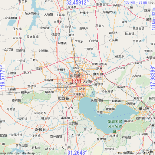
Hefei GPS coordinates[2]
31° 51' 50.004" North, 117° 16' 50.988" East
| Map corner | latitude | longitude |
|---|---|---|
| Upper-left | 32.45912°, | 116.57771° |
| Center: | 31.86389°, | 117.28083° |
| Lower-right: | 31.2648°, | 117.98396° |
| Map W x H: | 132.8×132.8 km | = 82.5×82.5mi |
| max Lat: | 53.31946° ⇑39.6% North |
| Hefei: | 31.86389° |
| min Lat: | ⇓60.4% South 18.22056° |
| min Long | Hefei | max Long |
| 75.07348° | 117.28083° | 134.28917° |
| W 67.7%⇐ | ⇒32.3% E |
Elevation
Elevation of Hefei is 24 m = 79 ft, and this is 460.8 m = 1512 ft below average elevation for this country.
| Max E: |
5622 m = 18445 ft | 81.2% |
| Avg. | 484.8 m = 1591 ft | |
| Hefei | 24 m = 79 ft | |
Min E: |
-3 m = -10 ft | 18.8% |
See also: Hefei elevation on elevation.city.
Geographical zone
Hefei is located in North temperate zone (between Tropic of Cancer and the Arctic Circle). Distance of this Northern Tropic circle is 937 km =582.2 mi to South.| Distance of | km | miles | from Hefei |
|---|---|---|---|
| North Pole | 6464.1 | 4016.6 | to North |
| Arctic Circle | 3858.2 | 2397.4 | to North |
| Tropic Cancer | 937 | 582.2 | to South |
| Equator | 3542.9 | 2201.5 | to South |


Nearby cities:
15 places around Hefei: (largest is in red/bold)
• Chaohu
62.7 km =39 mi,  117°
117°
• Chengjia
75.9 km =47.2 mi,  86°
86°
• Dianbu
16.8 km =10.4 mi, 86°
• Dingcheng
80.8 km =50.2 mi,  26°
26°
• Erlangkou
80.8 km =50.2 mi,  81°
81°
• Hengtanggang
82.1 km =51 mi,  244°
244°
• Huanfeng
79.1 km =49.2 mi,  101°
101°
• Lucheng
70.1 km =43.6 mi,  180°
180°
• Lu’an
73.6 km =45.7 mi,  258°
258°
• Quedian
75.1 km =46.7 mi,  213°
213°
• Shangpai
17.3 km =10.7 mi,  220°
220°
• Shucheng Chengguanzhen
53.3 km =33.1 mi, 215°
• Xianzong
69 km =42.9 mi, 95°
• Xiexiang
72.3 km =44.9 mi, 93°
• Yaokou
80.4 km =50 mi,  324°
324°
Sources, notices
• [Note1] Compared only with cities in China existing in our database
• [Src1] Map data: © OpenStreetMap contributors (CC-BY-SA)
• [Src2] Other city data from geonames.org with taken over terms of usage.
• [Src3] Geographical zone / Annual Mean Temperature by Robert A. Rohde @ Wikipedia
