Longxing geodata
Longxing (Chongqing) is a seat of a fourth-order administrative division; located in China in Asia/Shanghai (GMT+8) time zone. In our database, there are 1268 cities with bigger population. Compared to other cities in China, 57.4% of cities are located further ↑North; 84.3% of cities are located further →East and 61.1% of cities have lower elevation than Longxing. Note1


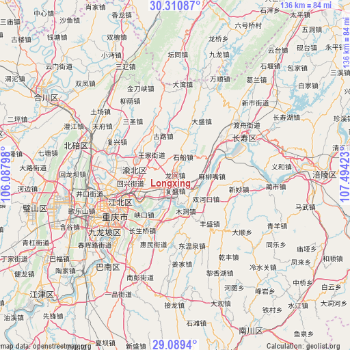
Longxing GPS coordinates[2]
29° 42' 7.164" North, 106° 47' 27.96" East
| Map corner | latitude | longitude |
|---|---|---|
| Upper-left | 30.31087°, | 106.08798° |
| Center: | 29.70199°, | 106.7911° |
| Lower-right: | 29.0894°, | 107.49423° |
| Map W x H: | 135.8×135.8 km | = 84.4×84.4mi |
| max Lat: | 53.31946° ⇑57.4% North |
| Longxing: | 29.70199° |
| min Lat: | ⇓42.6% South 18.22056° |
| min Long | Longxing | max Long |
| 75.07348° | 106.7911° | 134.28917° |
| W 15.7%⇐ | ⇒84.3% E |
Elevation
Elevation of Longxing is 273 m = 896 ft, and this is 211.8 m = 695 ft below average elevation for this country.
| Max E: |
5622 m = 18445 ft | 38.9% |
| Avg. | 484.8 m = 1591 ft | |
| Longxing | 273 m = 896 ft | |
Min E: |
-3 m = -10 ft | 61.1% |
See also: China elevation on elevation.city.
Geographical zone
Longxing is located in North temperate zone (between Tropic of Cancer and the Arctic Circle). Distance of this Northern Tropic circle is 696.6 km =432.8 mi to South.| Distance of | km | miles | from Longxing |
|---|---|---|---|
| North Pole | 6704.5 | 4166 | to North |
| Arctic Circle | 4098.6 | 2546.8 | to North |
| Tropic Cancer | 696.6 | 432.8 | to South |
| Equator | 3302.6 | 2052.1 | to South |


Nearby cities:
15 places around Longxing: (largest is in red/bold)
• Fusheng
6.1 km =3.8 mi,  179°
179°
• Guangyang
13.7 km =8.5 mi,  195°
195°
• Gulu
15.9 km =9.9 mi,  342°
342°
• Huixing
17.1 km =10.6 mi,  263°
263°
• Luoqi
13.8 km =8.6 mi,  84°
84°
• Maliuzui
14.8 km =9.2 mi,  93°
93°
• Mudong
14.9 km =9.3 mi,  161°
161°
• Mu’er
18.3 km =11.4 mi,  309°
309°
• Shichuan
7.7 km =4.8 mi,  23°
23°
• Shuangfengqiao
15.9 km =9.9 mi,  276°
276°
• Shuanghekou
15.4 km =9.6 mi,  127°
127°
• Tongjing
17.9 km =11.1 mi, 16°
• Wubao
8.6 km =5.3 mi,  153°
153°
• Yufengshan
12.8 km =8 mi,  250°
250°
• Yuzui
9.5 km =5.9 mi, 197°
Sources, notices
• [Note1] Compared only with cities in China existing in our database
• [Src1] Map data: © OpenStreetMap contributors (CC-BY-SA)
• [Src2] Other city data from geonames.org with taken over terms of usage.
• [Src3] Geographical zone / Annual Mean Temperature by Robert A. Rohde @ Wikipedia
