Fusheng geodata
Fusheng (Chongqing) is a seat of a fourth-order administrative division; located in China in Asia/Shanghai (GMT+8) time zone. In our database, there are 1268 cities with bigger population. Compared to other cities in China, 58% of cities are located further ↑North; 84.3% of cities are located further →East and 57.6% of cities have lower elevation than Fusheng. Note1


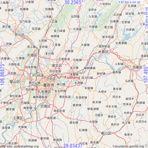
Fusheng GPS coordinates[2]
29° 38' 50.244" North, 106° 47' 30.732" East
| Map corner | latitude | longitude |
|---|---|---|
| Upper-left | 30.2565°, | 106.08875° |
| Center: | 29.64729°, | 106.79187° |
| Lower-right: | 29.03437°, | 107.495° |
| Map W x H: | 135.9×135.9 km | = 84.4×84.4mi |
| max Lat: | 53.31946° ⇑58% North |
| Fusheng: | 29.64729° |
| min Lat: | ⇓42% South 18.22056° |
| min Long | Fusheng | max Long |
| 75.07348° | 106.79187° | 134.28917° |
| W 15.7%⇐ | ⇒84.3% E |
Elevation
Elevation of Fusheng is 231 m = 758 ft, and this is 253.8 m = 833 ft below average elevation for this country.
| Max E: |
5622 m = 18445 ft | 42.4% |
| Avg. | 484.8 m = 1591 ft | |
| Fusheng | 231 m = 758 ft | |
Min E: |
-3 m = -10 ft | 57.6% |
See also: China elevation on elevation.city.
Geographical zone
Fusheng is located in North temperate zone (between Tropic of Cancer and the Arctic Circle). Distance of this Northern Tropic circle is 690.6 km =429.1 mi to South.| Distance of | km | miles | from Fusheng |
|---|---|---|---|
| North Pole | 6710.6 | 4169.8 | to North |
| Arctic Circle | 4104.7 | 2550.5 | to North |
| Tropic Cancer | 690.6 | 429.1 | to South |
| Equator | 3296.5 | 2048.3 | to South |


Nearby cities:
15 places around Fusheng: (largest is in red/bold)
• Fengsheng
18.7 km =11.6 mi,  133°
133°
• Guangyang
8 km =5 mi,  208°
208°
• Huixing
17.6 km =10.9 mi,  283°
283°
• Jiguanshi
19 km =11.8 mi,  252°
252°
• Longxing
6.1 km =3.8 mi,  359°
359°
• Luoqi
15.6 km =9.7 mi,  61°
61°
• Maliuzui
15.5 km =9.6 mi,  70°
70°
• Mudong
9.3 km =5.8 mi,  149°
149°
• Shichuan
13.5 km =8.4 mi,  12°
12°
• Shuangfengqiao
17.8 km =11.1 mi,  296°
296°
• Shuanghekou
12.6 km =7.8 mi,  104°
104°
• Wubao
4.1 km =2.5 mi,  114°
114°
• Yinglong
16 km =9.9 mi, 207°
• Yufengshan
12.3 km =7.6 mi, 278°
• Yuzui
4.2 km =2.6 mi,  224°
224°
Sources, notices
• [Note1] Compared only with cities in China existing in our database
• [Src1] Map data: © OpenStreetMap contributors (CC-BY-SA)
• [Src2] Other city data from geonames.org with taken over terms of usage.
• [Src3] Geographical zone / Annual Mean Temperature by Robert A. Rohde @ Wikipedia
