Liujiaxia geodata
Liujiaxia (Gansu) is a seat of a third-order administrative division; located in China in Asia/Shanghai (GMT+8) time zone. In our database, there are 1268 cities with bigger population. Compared to other cities in China, 77.1% of cities are located further ↓South; 91.1% of cities are located further →East and 92.5% of cities have lower elevation than Liujiaxia. Note1


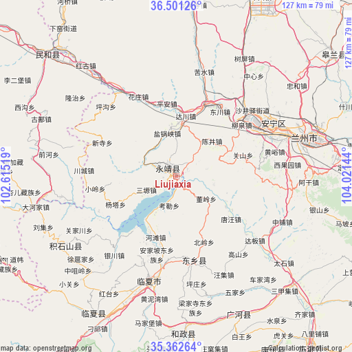
Liujiaxia GPS coordinates[2]
35° 56' 2.4" North, 103° 19' 5.916" East
| Map corner | latitude | longitude |
|---|---|---|
| Upper-left | 36.50126°, | 102.61519° |
| Center: | 35.934°, | 103.31831° |
| Lower-right: | 35.36264°, | 104.02144° |
| Map W x H: | 126.6×126.6 km | = 78.7×78.7mi |
| max Lat: | 53.31946° ⇑22.9% North |
| Liujiaxia: | 35.934° |
| min Lat: | ⇓77.1% South 18.22056° |
| min Long | Liujiaxia | max Long |
| 75.07348° | 103.31831° | 134.28917° |
| W 8.9%⇐ | ⇒91.1% E |
Elevation
Elevation of Liujiaxia is 1643 m = 5390 ft, and this is 1158.2 m = 3800 ft above average elevation for this country.
| Max E: |
5622 m = 18445 ft | 7.5% |
| Liujiaxia | 1643 m 5390 ft | |
| Avg. | 484.8 m = 1591 ft | |
Min E: |
-3 m = -10 ft | 92.5% |
See also: China elevation on elevation.city.
Geographical zone
Liujiaxia is located in North temperate zone (between Tropic of Cancer and the Arctic Circle). Distance of this Northern Tropic circle is 1389.6 km =863.5 mi to South.| Distance of | km | miles | from Liujiaxia |
|---|---|---|---|
| North Pole | 6011.6 | 3735.4 | to North |
| Arctic Circle | 3405.7 | 2116.2 | to North |
| Tropic Cancer | 1389.6 | 863.5 | to South |
| Equator | 3995.5 | 2482.7 | to South |


Nearby cities:
15 places around Liujiaxia: (largest is in red/bold)
• Anning Xilu
40.7 km =25.3 mi,  62°
62°
• Chuimatan
46.7 km =29 mi,  239°
239°
• Fulilu
32.6 km =20.3 mi, 55°
• Guanjiachuan
39.5 km =24.5 mi, 241°
• Guogan
43 km =26.7 mi,  223°
223°
• Hulinjia
41.4 km =25.7 mi, 235°
• Juiji
47.1 km =29.3 mi,  227°
227°
• Linxia Chengguanzhen
38.5 km =23.9 mi,  195°
195°
• Liugou
46.9 km =29.1 mi, 243°
• Suonan
30.6 km =19 mi,  166°
166°
• Wangjia
46.3 km =28.8 mi,  280°
280°
• Xiaoling
29.4 km =18.3 mi,  261°
261°
• Xihu
43.8 km =27.2 mi,  70°
70°
• Xinjia
43.6 km =27.1 mi, 261°
• Xuhujia
44.6 km =27.7 mi, 227°
Sources, notices
• [Note1] Compared only with cities in China existing in our database
• [Src1] Map data: © OpenStreetMap contributors (CC-BY-SA)
• [Src2] Other city data from geonames.org with taken over terms of usage.
• [Src3] Geographical zone / Annual Mean Temperature by Robert A. Rohde @ Wikipedia
