Xiaoyan geodata
Xiaoyan (Hubei) is a seat of a fourth-order administrative division; located in China in Asia/Shanghai (GMT+8) time zone. In our database, there are 1268 cities with bigger population. Compared to other cities in China, 58.3% of cities are located further ↓South; 63.7% of cities are located further →East and 69.5% of cities have lower elevation than Xiaoyan. Note1


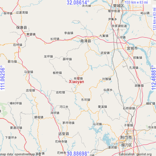
Xiaoyan GPS coordinates[2]
31° 29' 18.528" North, 111° 45' 56.448" East
| Map corner | latitude | longitude |
|---|---|---|
| Upper-left | 32.08614°, | 111.06256° |
| Center: | 31.48848°, | 111.76568° |
| Lower-right: | 30.88698°, | 112.46881° |
| Map W x H: | 133.3×133.3 km | = 82.8×82.8mi |
| max Lat: | 53.31946° ⇑41.7% North |
| Xiaoyan: | 31.48848° |
| min Lat: | ⇓58.3% South 18.22056° |
| min Long | Xiaoyan | max Long |
| 75.07348° | 111.76568° | 134.28917° |
| W 36.3%⇐ | ⇒63.7% E |
Elevation
Elevation of Xiaoyan is 402 m = 1319 ft, and this is 82.8 m = 272 ft below average elevation for this country.
| Max E: |
5622 m = 18445 ft | 30.5% |
| Avg. | 484.8 m = 1591 ft | |
| Xiaoyan | 402 m = 1319 ft | |
Min E: |
-3 m = -10 ft | 69.5% |
See also: China elevation on elevation.city.
Geographical zone
Xiaoyan is located in North temperate zone (between Tropic of Cancer and the Arctic Circle). Distance of this Northern Tropic circle is 895.3 km =556.3 mi to South.| Distance of | km | miles | from Xiaoyan |
|---|---|---|---|
| North Pole | 6505.9 | 4042.6 | to North |
| Arctic Circle | 3900 | 2423.3 | to North |
| Tropic Cancer | 895.3 | 556.3 | to South |
| Equator | 3501.2 | 2175.5 | to South |


Nearby cities:
15 places around Xiaoyan: (largest is in red/bold)
• Banqiao
17.6 km =10.9 mi,  285°
285°
• Changping
39.1 km =24.3 mi,  329°
329°
• Chengguan
33.5 km =20.8 mi,  12°
12°
• Donggong
19.1 km =11.9 mi,  160°
160°
• Hekou
27.1 km =16.8 mi,  206°
206°
• Limiao
39.1 km =24.3 mi,  347°
347°
• Liuhou
24.3 km =15.1 mi,  91°
91°
• Lixi
31.8 km =19.8 mi,  139°
139°
• Longping
31.7 km =19.7 mi,  306°
306°
• Maopingchang
39.4 km =24.5 mi,  192°
192°
• Nanzhang Chengguanzhen
33.4 km =20.8 mi, 10°
• Xianju
27.3 km =17 mi,  111°
111°
• Xueping
18.9 km =11.7 mi, 330°
• Xunjian
18.5 km =11.5 mi,  232°
232°
• Yangping
35.6 km =22.1 mi, 214°
Sources, notices
• [Note1] Compared only with cities in China existing in our database
• [Src1] Map data: © OpenStreetMap contributors (CC-BY-SA)
• [Src2] Other city data from geonames.org with taken over terms of usage.
• [Src3] Geographical zone / Annual Mean Temperature by Robert A. Rohde @ Wikipedia
