Xueping geodata
Xueping (Hubei) is a seat of a fourth-order administrative division; located in China in Asia/Shanghai (GMT+8) time zone. In our database, there are 1268 cities with bigger population. Compared to other cities in China, 59.2% of cities are located further ↓South; 64.2% of cities are located further →East and 82.5% of cities have lower elevation than Xueping. Note1


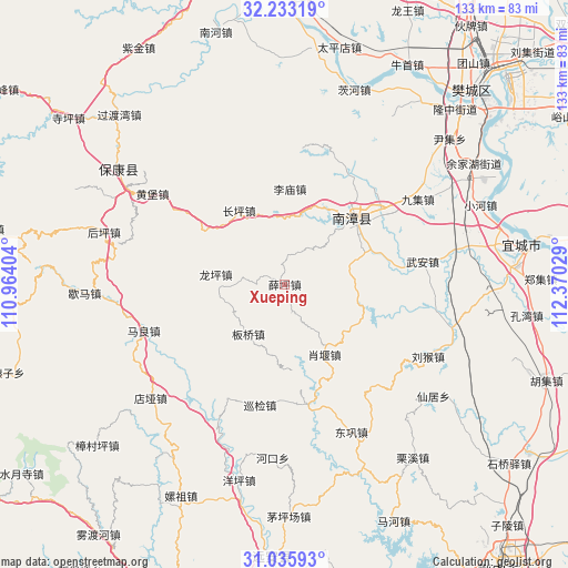
Xueping GPS coordinates[2]
31° 38' 11.364" North, 111° 40' 1.776" East
| Map corner | latitude | longitude |
|---|---|---|
| Upper-left | 32.23319°, | 110.96404° |
| Center: | 31.63649°, | 111.66716° |
| Lower-right: | 31.03593°, | 112.37029° |
| Map W x H: | 133.1×133.1 km | = 82.7×82.7mi |
| max Lat: | 53.31946° ⇑40.8% North |
| Xueping: | 31.63649° |
| min Lat: | ⇓59.2% South 18.22056° |
| min Long | Xueping | max Long |
| 75.07348° | 111.66716° | 134.28917° |
| W 35.8%⇐ | ⇒64.2% E |
Elevation
Elevation of Xueping is 821 m = 2694 ft, and this is 336.2 m = 1103 ft above average elevation for this country.
| Max E: |
5622 m = 18445 ft | 17.5% |
| Xueping | 821 m 2694 ft | |
| Avg. | 484.8 m = 1591 ft | |
Min E: |
-3 m = -10 ft | 82.5% |
See also: China elevation on elevation.city.
Geographical zone
Xueping is located in North temperate zone (between Tropic of Cancer and the Arctic Circle). Distance of this Northern Tropic circle is 911.7 km =566.5 mi to South.| Distance of | km | miles | from Xueping |
|---|---|---|---|
| North Pole | 6489.4 | 4032.3 | to North |
| Arctic Circle | 3883.5 | 2413.1 | to North |
| Tropic Cancer | 911.7 | 566.5 | to South |
| Equator | 3517.6 | 2185.7 | to South |


Nearby cities:
15 places around Xueping: (largest is in red/bold)
• Banqiao
14.1 km =8.8 mi,  212°
212°
• Changping
20.2 km =12.6 mi,  327°
327°
• Chengguan
23.3 km =14.5 mi,  45°
45°
• Dianya
41.2 km =25.6 mi,  230°
230°
• Donggong
37.9 km =23.5 mi,  155°
155°
• Hekou
40.8 km =25.4 mi,  183°
183°
• Huangbao
37.5 km =23.3 mi,  304°
304°
• Limiao
21.8 km =13.5 mi,  2°
2°
• Liuhou
37.6 km =23.4 mi,  116°
116°
• Longping
16.3 km =10.1 mi,  278°
278°
• Maliang
34.8 km =21.6 mi,  251°
251°
• Nanzhang Chengguanzhen
22.3 km =13.9 mi,  42°
42°
• Xiangcheng
40.9 km =25.4 mi, 35°
• Xiaoyan
18.9 km =11.7 mi,  150°
150°
• Xunjian
28.4 km =17.6 mi,  190°
190°
Sources, notices
• [Note1] Compared only with cities in China existing in our database
• [Src1] Map data: © OpenStreetMap contributors (CC-BY-SA)
• [Src2] Other city data from geonames.org with taken over terms of usage.
• [Src3] Geographical zone / Annual Mean Temperature by Robert A. Rohde @ Wikipedia
