Datong geodata
Datong (Hubei) is a seat of a fourth-order administrative division; located in China in Asia/Shanghai (GMT+8) time zone. In our database, there are 1268 cities with bigger population. Compared to other cities in China, 50.3% of cities are located further ↓South; 58.9% of cities are located further ←West and 61.3% of cities have higher elevation than Datong. Note1


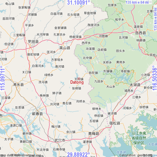
Datong GPS coordinates[2]
30° 29' 49.02" North, 115° 48' 0.828" East
| Map corner | latitude | longitude |
|---|---|---|
| Upper-left | 31.10091°, | 115.09711° |
| Center: | 30.49695°, | 115.80023° |
| Lower-right: | 29.88922°, | 116.50336° |
| Map W x H: | 134.7×134.7 km | = 83.7×83.7mi |
| max Lat: | 53.31946° ⇑49.7% North |
| Datong: | 30.49695° |
| min Lat: | ⇓50.3% South 18.22056° |
| min Long | Datong | max Long |
| 75.07348° | 115.80023° | 134.28917° |
| W 58.9%⇐ | ⇒41.1% E |
Elevation
Elevation of Datong is 91 m = 299 ft, and this is 393.8 m = 1292 ft below average elevation for this country.
| Max E: |
5622 m = 18445 ft | 61.3% |
| Avg. | 484.8 m = 1591 ft | |
| Datong | 91 m = 299 ft | |
Min E: |
-3 m = -10 ft | 38.7% |
See also: China elevation on elevation.city.
Geographical zone
Datong is located in North temperate zone (between Tropic of Cancer and the Arctic Circle). Distance of this Northern Tropic circle is 785 km =487.8 mi to South.| Distance of | km | miles | from Datong |
|---|---|---|---|
| North Pole | 6616.1 | 4111.1 | to North |
| Arctic Circle | 4010.2 | 2491.8 | to North |
| Tropic Cancer | 785 | 487.8 | to South |
| Equator | 3390.9 | 2107 | to South |


Nearby cities:
15 places around Datong: (largest is in red/bold)
• Fangjiazui
24.8 km =15.4 mi,  311°
311°
• Hongshan
33.6 km =20.9 mi,  334°
334°
• Kuanghe
32.9 km =20.4 mi, 314°
• Liuhe
30.5 km =19 mi,  224°
224°
• Liulin
29.5 km =18.3 mi,  149°
149°
• Lüyang
25.7 km =16 mi,  277°
277°
• Nanhe
19.5 km =12.1 mi,  303°
303°
• Qingshi
23.1 km =14.4 mi,  206°
206°
• Shizi
22.5 km =14 mi,  237°
237°
• Tanlin
5.4 km =3.4 mi,  60°
60°
• Tingqian
35.9 km =22.3 mi, 151°
• Xiangqiao
18.6 km =11.6 mi,  194°
194°
• Xima
31.4 km =19.5 mi,  264°
264°
• Zhangbang
8.2 km =5.1 mi, 192°
• Zhulin
32.8 km =20.4 mi, 244°
Sources, notices
• [Note1] Compared only with cities in China existing in our database
• [Src1] Map data: © OpenStreetMap contributors (CC-BY-SA)
• [Src2] Other city data from geonames.org with taken over terms of usage.
• [Src3] Geographical zone / Annual Mean Temperature by Robert A. Rohde @ Wikipedia
