Ruzhou geodata
Ruzhou (Henan) is a seat of a third-order administrative division; located in China in Asia/Shanghai (GMT+8) time zone. In our database, there are 1268 cities with bigger population. Compared to other cities in China, 70.9% of cities are located further ↓South; 58.5% of cities are located further →East and 55.4% of cities have lower elevation than Ruzhou. Note1


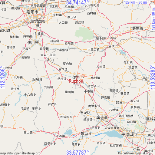
Ruzhou GPS coordinates[2]
34° 9' 42.012" North, 112° 49' 46.992" East
| Map corner | latitude | longitude |
|---|---|---|
| Upper-left | 34.74147°, | 112.1266° |
| Center: | 34.16167°, | 112.82972° |
| Lower-right: | 33.57787°, | 113.53285° |
| Map W x H: | 129.4×129.4 km | = 80.4×80.4mi |
| max Lat: | 53.31946° ⇑29.1% North |
| Ruzhou: | 34.16167° |
| min Lat: | ⇓70.9% South 18.22056° |
| min Long | Ruzhou | max Long |
| 75.07348° | 112.82972° | 134.28917° |
| W 41.5%⇐ | ⇒58.5% E |
Elevation
Elevation of Ruzhou is 210 m = 689 ft, and this is 274.8 m = 902 ft below average elevation for this country.
| Max E: |
5622 m = 18445 ft | 44.6% |
| Avg. | 484.8 m = 1591 ft | |
| Ruzhou | 210 m = 689 ft | |
Min E: |
-3 m = -10 ft | 55.4% |
See also: China elevation on elevation.city.
Geographical zone
Ruzhou is located in North temperate zone (between Tropic of Cancer and the Arctic Circle). Distance of this Northern Tropic circle is 1192.5 km =741 mi to South.| Distance of | km | miles | from Ruzhou |
|---|---|---|---|
| North Pole | 6208.6 | 3857.8 | to North |
| Arctic Circle | 3602.8 | 2238.7 | to North |
| Tropic Cancer | 1192.5 | 741 | to South |
| Equator | 3798.4 | 2360.2 | to South |


Nearby cities:
15 places around Ruzhou: (largest is in red/bold)
• Beizi
30.3 km =18.8 mi,  223°
223°
• Cangtou
32 km =19.9 mi,  186°
186°
• Ciba
22.6 km =14 mi,  114°
114°
• Daying
25.4 km =15.8 mi,  168°
168°
• Guanyinsi
34 km =21.1 mi,  195°
195°
• Huangdao
32.1 km =19.9 mi, 108°
• Liangwa
36.2 km =22.5 mi, 165°
• Nanguzhuang
29.4 km =18.3 mi, 171°
• Qianying
21.5 km =13.4 mi,  160°
160°
• Ruyang Chengguanzhen
34.2 km =21.3 mi,  267°
267°
• Shangjiuwu
27.3 km =17 mi,  150°
150°
• Wawu
34 km =21.1 mi,  207°
207°
• Xiaoqi
34.6 km =21.5 mi,  142°
142°
• Xuedian
29 km =18 mi,  125°
125°
• Zhangbaqiao
34.6 km =21.5 mi, 159°
Sources, notices
• [Note1] Compared only with cities in China existing in our database
• [Src1] Map data: © OpenStreetMap contributors (CC-BY-SA)
• [Src2] Other city data from geonames.org with taken over terms of usage.
• [Src3] Geographical zone / Annual Mean Temperature by Robert A. Rohde @ Wikipedia
