Juncheng geodata
Juncheng (Hebei) is a seat of a fourth-order administrative division; located in China in Asia/Shanghai (GMT+8) time zone. In our database, there are 1268 cities with bigger population. Compared to other cities in China, 82.6% of cities are located further ↓South; 52.6% of cities are located further ←West and 58.3% of cities have lower elevation than Juncheng. Note1


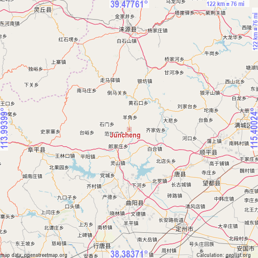
Juncheng GPS coordinates[2]
38° 55' 57.972" North, 114° 41' 49.596" East
| Map corner | latitude | longitude |
|---|---|---|
| Upper-left | 39.47761°, | 113.99399° |
| Center: | 38.93277°, | 114.69711° |
| Lower-right: | 38.38371°, | 115.40024° |
| Map W x H: | 121.6×121.6 km | = 75.6×75.6mi |
| max Lat: | 53.31946° ⇑17.4% North |
| Juncheng: | 38.93277° |
| min Lat: | ⇓82.6% South 18.22056° |
| min Long | Juncheng | max Long |
| 75.07348° | 114.69711° | 134.28917° |
| W 52.6%⇐ | ⇒47.4% E |
Elevation
Elevation of Juncheng is 239 m = 784 ft, and this is 245.8 m = 806 ft below average elevation for this country.
| Max E: |
5622 m = 18445 ft | 41.7% |
| Avg. | 484.8 m = 1591 ft | |
| Juncheng | 239 m = 784 ft | |
Min E: |
-3 m = -10 ft | 58.3% |
See also: China elevation on elevation.city.
Geographical zone
Juncheng is located in North temperate zone (between Tropic of Cancer and the Arctic Circle). Distance of this Northern Tropic circle is 1723 km =1070.6 mi to South.| Distance of | km | miles | from Juncheng |
|---|---|---|---|
| North Pole | 5678.1 | 3528.2 | to North |
| Arctic Circle | 3072.3 | 1909 | to North |
| Tropic Cancer | 1723 | 1070.6 | to South |
| Equator | 4328.9 | 2689.9 | to South |


Nearby cities:
15 places around Juncheng: (largest is in red/bold)
• Baihe
14.8 km =9.2 mi,  127°
127°
• Beidiantou
22.7 km =14.1 mi, 131°
• Beitai
15.6 km =9.7 mi,  234°
234°
• Dabei
20 km =12.4 mi,  76°
76°
• Dayang
19.9 km =12.4 mi,  154°
154°
• Fanjiazhuang
7.7 km =4.8 mi,  254°
254°
• Langjiazhuang
9.4 km =5.8 mi,  213°
213°
• Lingshan
16.8 km =10.4 mi,  198°
198°
• Micheng
10.1 km =6.3 mi,  139°
139°
• Pingyang
23.5 km =14.6 mi,  236°
236°
• Qijiazuo
12.3 km =7.6 mi,  90°
90°
• Shennan
17.2 km =10.7 mi,  67°
67°
• Shimen
11 km =6.8 mi,  283°
283°
• Taiyu
20 km =12.4 mi,  266°
266°
• Yangjiao
5.6 km =3.5 mi,  358°
358°
Sources, notices
• [Note1] Compared only with cities in China existing in our database
• [Src1] Map data: © OpenStreetMap contributors (CC-BY-SA)
• [Src2] Other city data from geonames.org with taken over terms of usage.
• [Src3] Geographical zone / Annual Mean Temperature by Robert A. Rohde @ Wikipedia
