Pingyang geodata
Pingyang (Hebei) is a seat of a fourth-order administrative division; located in China in Asia/Shanghai (GMT+8) time zone. In our database, there are 1268 cities with bigger population. Compared to other cities in China, 82.3% of cities are located further ↓South; 51.4% of cities are located further ←West and 56.9% of cities have lower elevation than Pingyang. Note1


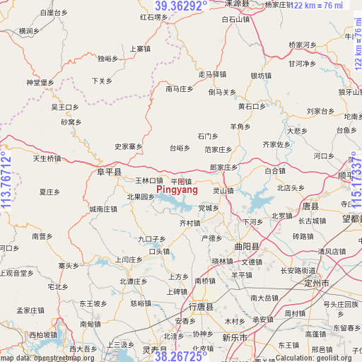
Pingyang GPS coordinates[2]
38° 49' 1.884" North, 114° 28' 12.864" East
| Map corner | latitude | longitude |
|---|---|---|
| Upper-left | 39.36292°, | 113.76712° |
| Center: | 38.81719°, | 114.47024° |
| Lower-right: | 38.26725°, | 115.17337° |
| Map W x H: | 121.8×121.8 km | = 75.7×75.7mi |
| max Lat: | 53.31946° ⇑17.7% North |
| Pingyang: | 38.81719° |
| min Lat: | ⇓82.3% South 18.22056° |
| min Long | Pingyang | max Long |
| 75.07348° | 114.47024° | 134.28917° |
| W 51.4%⇐ | ⇒48.6% E |
Elevation
Elevation of Pingyang is 225 m = 738 ft, and this is 259.8 m = 852 ft below average elevation for this country.
| Max E: |
5622 m = 18445 ft | 43.1% |
| Avg. | 484.8 m = 1591 ft | |
| Pingyang | 225 m = 738 ft | |
Min E: |
-3 m = -10 ft | 56.9% |
See also: China elevation on elevation.city.
Geographical zone
Pingyang is located in North temperate zone (between Tropic of Cancer and the Arctic Circle). Distance of this Northern Tropic circle is 1710.1 km =1062.6 mi to South.| Distance of | km | miles | from Pingyang |
|---|---|---|---|
| North Pole | 5691 | 3536.2 | to North |
| Arctic Circle | 3085.1 | 1917 | to North |
| Tropic Cancer | 1710.1 | 1062.6 | to South |
| Equator | 4316.1 | 2681.9 | to South |


Nearby cities:
15 places around Pingyang: (largest is in red/bold)
• Beiguoyuan
14.1 km =8.8 mi,  250°
250°
• Beihe
20.8 km =12.9 mi,  173°
173°
• Beitai
7.9 km =4.9 mi,  61°
61°
• Chande
21.5 km =13.4 mi,  152°
152°
• Dangcheng
12.6 km =7.8 mi,  135°
135°
• Datai
20.1 km =12.5 mi,  335°
335°
• Fanjiazhuang
16.3 km =10.1 mi,  48°
48°
• Jiukouzi
21.6 km =13.4 mi,  207°
207°
• Langjiazhuang
15.3 km =9.5 mi,  70°
70°
• Lingshan
14.6 km =9.1 mi,  101°
101°
• Qicun
13.9 km =8.6 mi, 168°
• Shijiazhai
21.3 km =13.2 mi,  304°
304°
• Shimen
17.8 km =11.1 mi,  30°
30°
• Taiyu
11.5 km =7.1 mi,  358°
358°
• Wanglinkou
11.1 km =6.9 mi,  272°
272°
Sources, notices
• [Note1] Compared only with cities in China existing in our database
• [Src1] Map data: © OpenStreetMap contributors (CC-BY-SA)
• [Src2] Other city data from geonames.org with taken over terms of usage.
• [Src3] Geographical zone / Annual Mean Temperature by Robert A. Rohde @ Wikipedia
