Lantang geodata
Lantang (Guangdong) is a seat of a fourth-order administrative division; located in China in Asia/Shanghai (GMT+8) time zone. In our database, there are 1268 cities with bigger population. Compared to other cities in China, 92.6% of cities are located further ↑North; 53.9% of cities are located further ←West and 68.4% of cities have higher elevation than Lantang. Note1


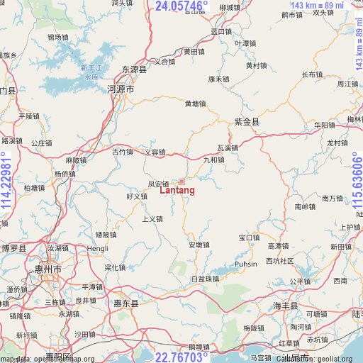
Lantang GPS coordinates[2]
23° 24' 49.752" North, 114° 55' 58.548" East
| Map corner | latitude | longitude |
|---|---|---|
| Upper-left | 24.05746°, | 114.22981° |
| Center: | 23.41382°, | 114.93293° |
| Lower-right: | 22.76703°, | 115.63606° |
| Map W x H: | 143.5×143.5 km | = 89.2×89.2mi |
| max Lat: | 53.31946° ⇑92.6% North |
| Lantang: | 23.41382° |
| min Lat: | ⇓7.4% South 18.22056° |
| min Long | Lantang | max Long |
| 75.07348° | 114.93293° | 134.28917° |
| W 53.9%⇐ | ⇒46.1% E |
Elevation
Elevation of Lantang is 58 m = 190 ft, and this is 426.8 m = 1400 ft below average elevation for this country.
| Max E: |
5622 m = 18445 ft | 68.4% |
| Avg. | 484.8 m = 1591 ft | |
| Lantang | 58 m = 190 ft | |
Min E: |
-3 m = -10 ft | 31.6% |
See also: China elevation on elevation.city.
Geographical zone
Lantang is located in North Torrid zone (between Equator and Tropic of Cancer). Distance of this Northern Tropic circle is 2.5 km =1.6 mi to North.| Distance of | km | miles | from Lantang |
|---|---|---|---|
| North Pole | 7403.7 | 4600.4 | to North |
| Arctic Circle | 4797.8 | 2981.2 | to North |
| Tropic Cancer | 2.5 | 1.6 | to North |
| Equator | 2603.4 | 1617.7 | to South |


Nearby cities:
15 places around Lantang: (largest is in red/bold)
• Andun
26.7 km =16.6 mi,  163°
163°
• Baipu
33.9 km =21.1 mi,  345°
345°
• Dalan
26.6 km =16.5 mi,  236°
236°
• Feng’an
8.9 km =5.5 mi,  268°
268°
• Fucheng
34.7 km =21.6 mi,  42°
42°
• Guzhu
25.8 km =16 mi,  296°
296°
• Haoyi
18.8 km =11.7 mi,  255°
255°
• Huangtang
31.5 km =19.6 mi,  10°
10°
• Jiuhe
15.9 km =9.9 mi,  55°
55°
• Jiushu
25.8 km =16 mi,  79°
79°
• Qingxi
13.9 km =8.6 mi, 8°
• Shangyi
18.6 km =11.6 mi,  216°
216°
• Songkeng
25.8 km =16 mi,  184°
184°
• Waxi
22.7 km =14.1 mi,  52°
52°
• Yirong
16 km =9.9 mi,  319°
319°
Sources, notices
• [Note1] Compared only with cities in China existing in our database
• [Src1] Map data: © OpenStreetMap contributors (CC-BY-SA)
• [Src2] Other city data from geonames.org with taken over terms of usage.
• [Src3] Geographical zone / Annual Mean Temperature by Robert A. Rohde @ Wikipedia
