Feng’an geodata
Feng’an (Guangdong) is a seat of a fourth-order administrative division; located in China in Asia/Shanghai (GMT+8) time zone. In our database, there are 1268 cities with bigger population. Compared to other cities in China, 92.6% of cities are located further ↑North; 53.3% of cities are located further ←West and 68.4% of cities have higher elevation than Feng’an. Note1


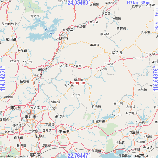
Feng’an GPS coordinates[2]
23° 24' 40.572" North, 114° 50' 44.268" East
| Map corner | latitude | longitude |
|---|---|---|
| Upper-left | 24.05493°, | 114.14251° |
| Center: | 23.41127°, | 114.84563° |
| Lower-right: | 22.76447°, | 115.54876° |
| Map W x H: | 143.5×143.5 km | = 89.2×89.2mi |
| max Lat: | 53.31946° ⇑92.6% North |
| Feng’an: | 23.41127° |
| min Lat: | ⇓7.4% South 18.22056° |
| min Long | Feng’an | max Long |
| 75.07348° | 114.84563° | 134.28917° |
| W 53.3%⇐ | ⇒46.7% E |
Elevation
Elevation of Feng’an is 58 m = 190 ft, and this is 426.8 m = 1400 ft below average elevation for this country.
| Max E: |
5622 m = 18445 ft | 68.4% |
| Avg. | 484.8 m = 1591 ft | |
| Feng’an | 58 m = 190 ft | |
Min E: |
-3 m = -10 ft | 31.6% |
See also: China elevation on elevation.city.
Geographical zone
Feng’an is located in North Torrid zone (between Equator and Tropic of Cancer). Distance of this Northern Tropic circle is 2.8 km =1.7 mi to North.| Distance of | km | miles | from Feng’an |
|---|---|---|---|
| North Pole | 7404 | 4600.6 | to North |
| Arctic Circle | 4798.1 | 2981.4 | to North |
| Tropic Cancer | 2.8 | 1.7 | to North |
| Equator | 2603.1 | 1617.5 | to South |


Nearby cities:
15 places around Feng’an: (largest is in red/bold)
• Aipi
29.4 km =18.3 mi,  226°
226°
• Andun
30.1 km =18.7 mi,  147°
147°
• Dalan
19.6 km =12.2 mi,  222°
222°
• Guanyinge
27.4 km =17 mi,  266°
266°
• Guzhu
18.4 km =11.4 mi,  309°
309°
• Haoyi
10.3 km =6.4 mi,  243°
243°
• Jiuhe
23.9 km =14.9 mi,  66°
66°
• Lantang
8.9 km =5.5 mi,  88°
88°
• Linjiang
30.8 km =19.1 mi,  329°
329°
• Qingxi
17.9 km =11.1 mi,  38°
38°
• Shangyi
14.8 km =9.2 mi,  188°
188°
• Shiba
31.1 km =19.3 mi,  296°
296°
• Songkeng
26.4 km =16.4 mi,  164°
164°
• Waxi
30.4 km =18.9 mi,  62°
62°
• Yirong
12.5 km =7.8 mi,  353°
353°
Sources, notices
• [Note1] Compared only with cities in China existing in our database
• [Src1] Map data: © OpenStreetMap contributors (CC-BY-SA)
• [Src2] Other city data from geonames.org with taken over terms of usage.
• [Src3] Geographical zone / Annual Mean Temperature by Robert A. Rohde @ Wikipedia
