Kunyang geodata
Kunyang (Zhejiang) is a populated place; located in China in Asia/Shanghai (GMT+8) time zone. With population of 65,009 people, there are 669 cities with bigger population in this country. Compared to other cities in China, 75.9% of cities are located further ↑North; 85.5% of cities are located further ←West and 52.6% of cities have higher elevation than Kunyang. Note1


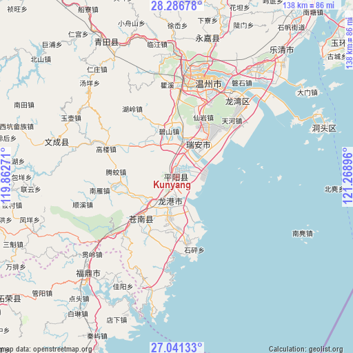
Kunyang GPS coordinates[2]
27° 39' 56.988" North, 120° 33' 56.988" East
| Map corner | latitude | longitude |
|---|---|---|
| Upper-left | 28.28678°, | 119.86271° |
| Center: | 27.66583°, | 120.56583° |
| Lower-right: | 27.04133°, | 121.26896° |
| Map W x H: | 138.5×138.5 km | = 86.1×86.1mi |
| max Lat: | 53.31946° ⇑75.9% North |
| Kunyang: | 27.66583° |
| min Lat: | ⇓24.1% South 18.22056° |
| min Long | Kunyang | max Long |
| 75.07348° | 120.56583° | 134.28917° |
| W 85.5%⇐ | ⇒14.5% E |
Elevation
Elevation of Kunyang is 146 m = 479 ft, and this is 338.8 m = 1112 ft below average elevation for this country.
| Max E: |
5622 m = 18445 ft | 52.6% |
| Avg. | 484.8 m = 1591 ft | |
| Kunyang | 146 m = 479 ft | |
Min E: |
-3 m = -10 ft | 47.4% |
See also: Kunyang elevation on elevation.city.
Geographical zone
Kunyang is located in North temperate zone (between Tropic of Cancer and the Arctic Circle). Distance of this Northern Tropic circle is 470.2 km =292.2 mi to South.| Distance of | km | miles | from Kunyang |
|---|---|---|---|
| North Pole | 6930.9 | 4306.7 | to North |
| Arctic Circle | 4325 | 2687.4 | to North |
| Tropic Cancer | 470.2 | 292.2 | to South |
| Equator | 3076.2 | 1911.5 | to South |


Nearby cities:
15 places around Kunyang: (largest is in red/bold)
• Fangshan
46.9 km =29.1 mi,  328°
328°
• Fuding
51.2 km =31.8 mi,  222°
222°
• Jinxiang
26.2 km =16.3 mi,  171°
171°
• Louqiao
38.9 km =24.2 mi,  9°
9°
• Oubei
43.2 km =26.8 mi, 11°
• Qidu
42.7 km =26.5 mi,  27°
27°
• Renzhuang
52.5 km =32.6 mi,  323°
323°
• Shankou
51.3 km =31.9 mi, 331°
• Shiqiao
35.2 km =21.9 mi,  358°
358°
• Shuangling
40.1 km =24.9 mi, 5°
• Shuangyu
39.5 km =24.5 mi, 5°
• Tengqiao
45.4 km =28.2 mi,  351°
351°
• Wenzhou
38.4 km =23.9 mi, 14°
• Wuma
40.3 km =25 mi, 14°
• Wuniu
47 km =29.2 mi, 28°
Sources, notices
• [Note1] Compared only with cities in China existing in our database
• [Src1] Map data: © OpenStreetMap contributors (CC-BY-SA)
• [Src2] Other city data from geonames.org with taken over terms of usage.
• [Src3] Geographical zone / Annual Mean Temperature by Robert A. Rohde @ Wikipedia
