Jinxiang geodata
Jinxiang (Zhejiang) is a populated place; located in China in Asia/Shanghai (GMT+8) time zone. With population of 84,231 people, there are 505 cities with bigger population in this country. Compared to other cities in China, 76.8% of cities are located further ↑North; 85.7% of cities are located further ←West and 89.9% of cities have higher elevation than Jinxiang. Note1


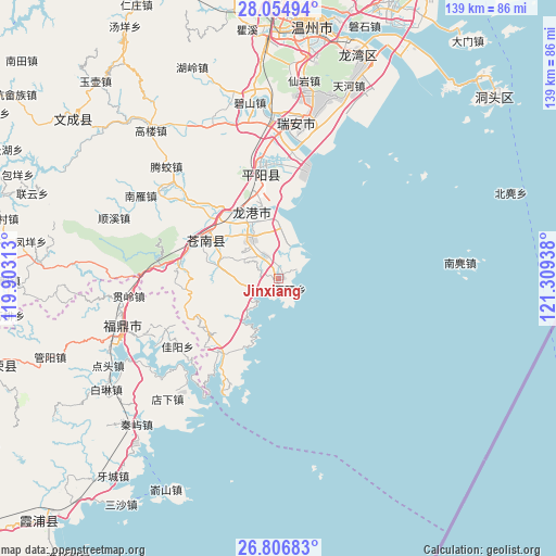
Jinxiang GPS coordinates[2]
27° 25' 57.54" North, 120° 36' 22.5" East
| Map corner | latitude | longitude |
|---|---|---|
| Upper-left | 28.05494°, | 119.90313° |
| Center: | 27.43265°, | 120.60625° |
| Lower-right: | 26.80683°, | 121.30938° |
| Map W x H: | 138.8×138.8 km | = 86.2×86.2mi |
| max Lat: | 53.31946° ⇑76.8% North |
| Jinxiang: | 27.43265° |
| min Lat: | ⇓23.2% South 18.22056° |
| min Long | Jinxiang | max Long |
| 75.07348° | 120.60625° | 134.28917° |
| W 85.7%⇐ | ⇒14.3% E |
Elevation
Elevation of Jinxiang is 10 m = 33 ft, and this is 474.8 m = 1558 ft below average elevation for this country.
| Max E: |
5622 m = 18445 ft | 89.9% |
| Avg. | 484.8 m = 1591 ft | |
| Jinxiang | 10 m = 33 ft | |
Min E: |
-3 m = -10 ft | 10.1% |
See also: Jinxiang elevation on elevation.city.
Geographical zone
Jinxiang is located in North temperate zone (between Tropic of Cancer and the Arctic Circle). Distance of this Northern Tropic circle is 444.3 km =276.1 mi to South.| Distance of | km | miles | from Jinxiang |
|---|---|---|---|
| North Pole | 6956.8 | 4322.8 | to North |
| Arctic Circle | 4350.9 | 2703.5 | to North |
| Tropic Cancer | 444.3 | 276.1 | to South |
| Equator | 3050.2 | 1895.3 | to South |


Nearby cities:
15 places around Jinxiang: (largest is in red/bold)
• Dongxi
63.8 km =39.6 mi,  269°
269°
• Fengyang
62.5 km =38.8 mi,  278°
278°
• Fuding
40.5 km =25.2 mi,  253°
253°
• Kunyang
26.2 km =16.3 mi,  351°
351°
• Lianyun
64.9 km =40.3 mi,  289°
289°
• Liufeng
60.6 km =37.7 mi, 265°
• Louqiao
64.3 km =40 mi,  2°
2°
• Qidu
65.8 km =40.9 mi,  13°
13°
• Shiqiao
61.3 km =38.1 mi,  355°
355°
• Shuangyu
65.2 km =40.5 mi, 0°
• Wengshan
64.3 km =40 mi, 283°
• Wenzhou
63.3 km =39.3 mi, 5°
• Wuma
65.3 km =40.6 mi, 5°
• Yacheng
64.4 km =40 mi,  219°
219°
• Yushan
59.8 km =37.2 mi,  207°
207°
Sources, notices
• [Note1] Compared only with cities in China existing in our database
• [Src1] Map data: © OpenStreetMap contributors (CC-BY-SA)
• [Src2] Other city data from geonames.org with taken over terms of usage.
• [Src3] Geographical zone / Annual Mean Temperature by Robert A. Rohde @ Wikipedia
