Hebi geodata
Hebi (Henan) is a populated place; located in China in Asia/Shanghai (GMT+8) time zone. With population of 244,662 people, there are 205 cities with bigger population in this country. Compared to other cities in China, 77% of cities are located further ↓South; 50.2% of cities are located further →East and 53.8% of cities have higher elevation than Hebi. Note1


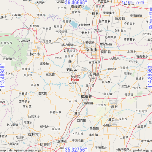
Hebi GPS coordinates[2]
35° 53' 57.012" North, 114° 11' 33" East
| Map corner | latitude | longitude |
|---|---|---|
| Upper-left | 36.46668°, | 113.48938° |
| Center: | 35.89917°, | 114.1925° |
| Lower-right: | 35.32756°, | 114.89563° |
| Map W x H: | 126.7×126.7 km | = 78.7×78.7mi |
| max Lat: | 53.31946° ⇑23% North |
| Hebi: | 35.89917° |
| min Lat: | ⇓77% South 18.22056° |
| min Long | Hebi | max Long |
| 75.07348° | 114.1925° | 134.28917° |
| W 49.8%⇐ | ⇒50.2% E |
Elevation
Elevation of Hebi is 138 m = 453 ft, and this is 346.8 m = 1138 ft below average elevation for this country.
| Max E: |
5622 m = 18445 ft | 53.8% |
| Avg. | 484.8 m = 1591 ft | |
| Hebi | 138 m = 453 ft | |
Min E: |
-3 m = -10 ft | 46.2% |
See also: Hebi elevation on elevation.city.
Geographical zone
Hebi is located in North temperate zone (between Tropic of Cancer and the Arctic Circle). Distance of this Northern Tropic circle is 1385.7 km =861 mi to South.| Distance of | km | miles | from Hebi |
|---|---|---|---|
| North Pole | 6015.4 | 3737.8 | to North |
| Arctic Circle | 3409.6 | 2118.6 | to North |
| Tropic Cancer | 1385.7 | 861 | to South |
| Equator | 3991.6 | 2480.3 | to South |


Nearby cities:
15 places around Hebi: (largest is in red/bold)
• Anyang
27.8 km =17.3 mi,  38°
38°
• Chaoge
32.7 km =20.3 mi,  180°
180°
• Chengguan
60.6 km =37.7 mi,  216°
216°
• Chengjiao
56.2 km =34.9 mi,  192°
192°
• Daokou
46.8 km =29.1 mi,  142°
142°
• Hecun
70.9 km =44.1 mi,  354°
354°
• Kaiyuan
38.3 km =23.8 mi,  299°
299°
• Linshui
58.4 km =36.3 mi,  1°
1°
• Neihuang Chengguanzhen
64.2 km =39.9 mi,  84°
84°
• Pengcheng
59.2 km =36.8 mi,  358°
358°
• Puyang
75.9 km =47.2 mi,  101°
101°
• Puyang Chengguanzhen
77.2 km =48 mi,  106°
106°
• Tangyang Chengguanzhen
14.7 km =9.1 mi, 83°
• Xun Xian Chengguanzhen
40.4 km =25.1 mi,  130°
130°
• Yigou
14.8 km =9.2 mi, 131°
Sources, notices
• [Note1] Compared only with cities in China existing in our database
• [Src1] Map data: © OpenStreetMap contributors (CC-BY-SA)
• [Src2] Other city data from geonames.org with taken over terms of usage.
• [Src3] Geographical zone / Annual Mean Temperature by Robert A. Rohde @ Wikipedia
