Daokou geodata
Daokou (Henan) is a seat of a third-order administrative division; located in China in Asia/Shanghai (GMT+8) time zone. With population of 56,637 people, there are 774 cities with bigger population in this country. Compared to other cities in China, 76.2% of cities are located further ↓South; 51.6% of cities are located further ←West and 67.2% of cities have higher elevation than Daokou. Note1


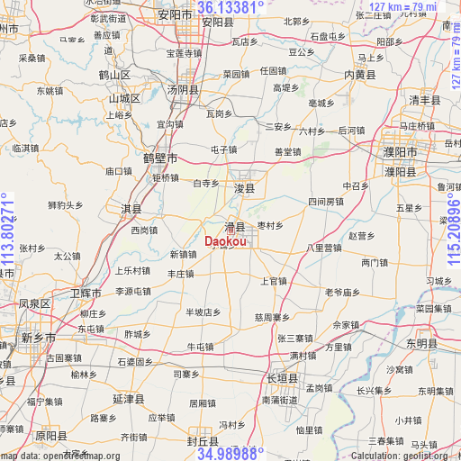
Daokou GPS coordinates[2]
35° 33' 50.004" North, 114° 30' 20.988" East
| Map corner | latitude | longitude |
|---|---|---|
| Upper-left | 36.13381°, | 113.80271° |
| Center: | 35.56389°, | 114.50583° |
| Lower-right: | 34.98988°, | 115.20896° |
| Map W x H: | 127.2×127.2 km | = 79×79mi |
| max Lat: | 53.31946° ⇑23.8% North |
| Daokou: | 35.56389° |
| min Lat: | ⇓76.2% South 18.22056° |
| min Long | Daokou | max Long |
| 75.07348° | 114.50583° | 134.28917° |
| W 51.6%⇐ | ⇒48.4% E |
Elevation
Elevation of Daokou is 64 m = 210 ft, and this is 420.8 m = 1381 ft below average elevation for this country.
| Max E: |
5622 m = 18445 ft | 67.2% |
| Avg. | 484.8 m = 1591 ft | |
| Daokou | 64 m = 210 ft | |
Min E: |
-3 m = -10 ft | 32.8% |
See also: Daokou elevation on elevation.city.
Geographical zone
Daokou is located in North temperate zone (between Tropic of Cancer and the Arctic Circle). Distance of this Northern Tropic circle is 1348.4 km =837.9 mi to South.| Distance of | km | miles | from Daokou |
|---|---|---|---|
| North Pole | 6052.7 | 3761 | to North |
| Arctic Circle | 3446.8 | 2141.7 | to North |
| Tropic Cancer | 1348.4 | 837.9 | to South |
| Equator | 3954.3 | 2457.1 | to South |


Nearby cities:
15 places around Daokou: (largest is in red/bold)
• Anyang
60.2 km =37.4 mi,  349°
349°
• Changyuan County
44.3 km =27.5 mi,  152°
152°
• Chaoge
29 km =18 mi,  279°
279°
• Chengjiao
44 km =27.3 mi,  246°
246°
• Fengqiu Chengguanzhen
60 km =37.3 mi,  188°
188°
• Hebi
46.8 km =29.1 mi,  322°
322°
• Neihuang Chengguanzhen
55.9 km =34.7 mi,  39°
39°
• Puxi
44 km =27.3 mi,  158°
158°
• Puyang
51.2 km =31.8 mi,  64°
64°
• Puyang Chengguanzhen
48.5 km =30.1 mi,  71°
71°
• Tangyang Chengguanzhen
41.3 km =25.7 mi,  340°
340°
• Xun Xian Chengguanzhen
11.5 km =7.1 mi,  13°
13°
• Yanjin Chengguanzhen
55.2 km =34.3 mi,  211°
211°
• Yigou
32.4 km =20.1 mi,  328°
328°
• Zhongyuanlu
55.1 km =34.2 mi, 65°
Sources, notices
• [Note1] Compared only with cities in China existing in our database
• [Src1] Map data: © OpenStreetMap contributors (CC-BY-SA)
• [Src2] Other city data from geonames.org with taken over terms of usage.
• [Src3] Geographical zone / Annual Mean Temperature by Robert A. Rohde @ Wikipedia
