Jiulong geodata
Jiulong (Guangdong) is a seat of a fourth-order administrative division; located in China in Asia/Shanghai (GMT+8) time zone. In our database, there are 1268 cities with bigger population. Compared to other cities in China, 89.9% of cities are located further ↑North; 58.1% of cities are located further →East and 60.4% of cities have higher elevation than Jiulong. Note1


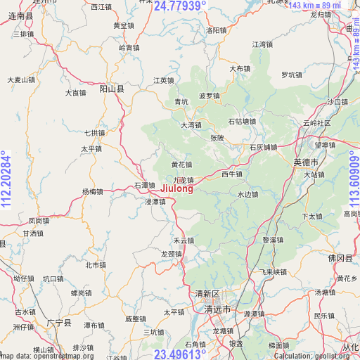
Jiulong GPS coordinates[2]
24° 8' 21.732" North, 112° 54' 21.456" East
| Map corner | latitude | longitude |
|---|---|---|
| Upper-left | 24.77939°, | 112.20284° |
| Center: | 24.13937°, | 112.90596° |
| Lower-right: | 23.49613°, | 113.60909° |
| Map W x H: | 142.7×142.7 km | = 88.7×88.7mi |
| max Lat: | 53.31946° ⇑89.9% North |
| Jiulong: | 24.13937° |
| min Lat: | ⇓10.1% South 18.22056° |
| min Long | Jiulong | max Long |
| 75.07348° | 112.90596° | 134.28917° |
| W 41.9%⇐ | ⇒58.1% E |
Elevation
Elevation of Jiulong is 96 m = 315 ft, and this is 388.8 m = 1276 ft below average elevation for this country.
| Max E: |
5622 m = 18445 ft | 60.4% |
| Avg. | 484.8 m = 1591 ft | |
| Jiulong | 96 m = 315 ft | |
Min E: |
-3 m = -10 ft | 39.6% |
See also: China elevation on elevation.city.
Geographical zone
Jiulong is located in North temperate zone (between Tropic of Cancer and the Arctic Circle). Distance of this Northern Tropic circle is 78.1 km =48.5 mi to South.| Distance of | km | miles | from Jiulong |
|---|---|---|---|
| North Pole | 7323 | 4550.3 | to North |
| Arctic Circle | 4717.1 | 2931.1 | to North |
| Tropic Cancer | 78.1 | 48.5 | to South |
| Equator | 2684 | 1667.8 | to South |


Nearby cities:
15 places around Jiulong: (largest is in red/bold)
• Dadong
20.6 km =12.8 mi,  126°
126°
• Dawan
22.7 km =14.1 mi,  8°
8°
• HanHuang
26.5 km =16.5 mi,  57°
57°
• Heyun
23.3 km =14.5 mi,  176°
176°
• Huanghua
7.8 km =4.8 mi,  356°
356°
• Jintan
13.3 km =8.3 mi,  228°
228°
• Longjing
30.8 km =19.1 mi,  193°
193°
• Mingjing
6.9 km =4.3 mi,  0°
0°
• Shaba
18.6 km =11.6 mi,  106°
106°
• Shahe
16.4 km =10.2 mi, 189°
• Shitan
14.5 km =9 mi,  265°
265°
• Shuibian
27.1 km =16.8 mi,  99°
99°
• Xiniu
21.1 km =13.1 mi,  82°
82°
• Yanbei
17.2 km =10.7 mi,  330°
330°
• Zhangbei
22.6 km =14 mi,  41°
41°
Sources, notices
• [Note1] Compared only with cities in China existing in our database
• [Src1] Map data: © OpenStreetMap contributors (CC-BY-SA)
• [Src2] Other city data from geonames.org with taken over terms of usage.
• [Src3] Geographical zone / Annual Mean Temperature by Robert A. Rohde @ Wikipedia
