Shahe geodata
Shahe (Guangdong) is a seat of a fourth-order administrative division; located in China in Asia/Shanghai (GMT+8) time zone. In our database, there are 1268 cities with bigger population. Compared to other cities in China, 90.5% of cities are located further ↑North; 58.3% of cities are located further →East and 72.7% of cities have higher elevation than Shahe. Note1


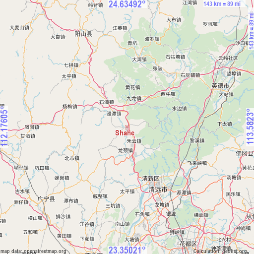
Shahe GPS coordinates[2]
23° 59' 39.012" North, 112° 52' 45.012" East
| Map corner | latitude | longitude |
|---|---|---|
| Upper-left | 24.63492°, | 112.17605° |
| Center: | 23.99417°, | 112.87917° |
| Lower-right: | 23.35021°, | 113.5823° |
| Map W x H: | 142.8×142.8 km | = 88.7×88.7mi |
| max Lat: | 53.31946° ⇑90.5% North |
| Shahe: | 23.99417° |
| min Lat: | ⇓9.5% South 18.22056° |
| min Long | Shahe | max Long |
| 75.07348° | 112.87917° | 134.28917° |
| W 41.7%⇐ | ⇒58.3% E |
Elevation
Elevation of Shahe is 43 m = 141 ft, and this is 441.8 m = 1449 ft below average elevation for this country.
| Max E: |
5622 m = 18445 ft | 72.7% |
| Avg. | 484.8 m = 1591 ft | |
| Shahe | 43 m = 141 ft | |
Min E: |
-3 m = -10 ft | 27.3% |
See also: China elevation on elevation.city.
Geographical zone
Shahe is located in North temperate zone (between Tropic of Cancer and the Arctic Circle). Distance of this Northern Tropic circle is 62 km =38.5 mi to South.| Distance of | km | miles | from Shahe |
|---|---|---|---|
| North Pole | 7339.2 | 4560.4 | to North |
| Arctic Circle | 4733.3 | 2941.1 | to North |
| Tropic Cancer | 62 | 38.5 | to South |
| Equator | 2667.9 | 1657.8 | to South |


Nearby cities:
15 places around Shahe: (largest is in red/bold)
• Dadong
19.7 km =12.2 mi,  78°
78°
• Dongcheng
34.4 km =21.4 mi,  147°
147°
• Fengcheng
32.6 km =20.3 mi, 151°
• Heyun
8.2 km =5.1 mi, 150°
• Huanghua
24 km =14.9 mi,  5°
5°
• Jintan
10.2 km =6.3 mi,  315°
315°
• Jiulong
16.4 km =10.2 mi, 9°
• Longjing
14.5 km =9 mi,  197°
197°
• Mingjing
23.2 km =14.4 mi, 6°
• Shaba
23.2 km =14.4 mi,  62°
62°
• Shitan
19 km =11.8 mi, 321°
• Shuibian
31.7 km =19.7 mi,  68°
68°
• Taihe
30.5 km =19 mi,  160°
160°
• Xiniu
30.2 km =18.8 mi,  51°
51°
• Yanbei
31.6 km =19.6 mi,  349°
349°
Sources, notices
• [Note1] Compared only with cities in China existing in our database
• [Src1] Map data: © OpenStreetMap contributors (CC-BY-SA)
• [Src2] Other city data from geonames.org with taken over terms of usage.
• [Src3] Geographical zone / Annual Mean Temperature by Robert A. Rohde @ Wikipedia
