Jinjiang geodata
Jinjiang (Hainan) is a seat of a third-order administrative division; located in China in Asia/Shanghai (GMT+8) time zone. With population of 68,720 people, there are 621 cities with bigger population in this country. Compared to other cities in China, 99% of cities are located further ↑North; 71.2% of cities are located further →East and 82.1% of cities have higher elevation than Jinjiang. Note1


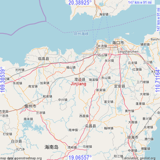
Jinjiang GPS coordinates[2]
19° 43' 43.608" North, 110° 0' 30.636" East
| Map corner | latitude | longitude |
|---|---|---|
| Upper-left | 20.38925°, | 109.30539° |
| Center: | 19.72878°, | 110.00851° |
| Lower-right: | 19.06557°, | 110.71164° |
| Map W x H: | 147.2×147.2 km | = 91.5×91.5mi |
| max Lat: | 53.31946° ⇑99% North |
| Jinjiang: | 19.72878° |
| min Lat: | ⇓1% South 18.22056° |
| min Long | Jinjiang | max Long |
| 75.07348° | 110.00851° | 134.28917° |
| W 28.8%⇐ | ⇒71.2% E |
Elevation
Elevation of Jinjiang is 22 m = 72 ft, and this is 462.8 m = 1518 ft below average elevation for this country.
| Max E: |
5622 m = 18445 ft | 82.1% |
| Avg. | 484.8 m = 1591 ft | |
| Jinjiang | 22 m = 72 ft | |
Min E: |
-3 m = -10 ft | 17.9% |
See also: Jinjiang elevation on elevation.city.
Geographical zone
Jinjiang is located in North Torrid zone (between Equator and Tropic of Cancer). Distance of this Northern Tropic circle is 412.3 km =256.2 mi to North.| Distance of | km | miles | from Jinjiang |
|---|---|---|---|
| North Pole | 7813.4 | 4855 | to North |
| Arctic Circle | 5207.5 | 3235.8 | to North |
| Tropic Cancer | 412.3 | 256.2 | to North |
| Equator | 2193.6 | 1363 | to South |


Nearby cities:
15 places around Jinjiang: (largest is in red/bold)
• Dongshan
23.6 km =14.7 mi,  83°
83°
• Duowen
25.9 km =16.1 mi,  281°
281°
• Fushan
14.7 km =9.1 mi,  324°
324°
• Huangtong
20.9 km =13 mi,  304°
304°
• Jiale
16.9 km =10.5 mi,  178°
178°
• Laocheng
28.6 km =17.8 mi,  23°
23°
• Longbo
16.8 km =10.4 mi, 282°
• Mei’an
24.9 km =15.5 mi,  48°
48°
• Qiaotou
27.6 km =17.1 mi,  341°
341°
• Ruixi
12.2 km =7.6 mi,  87°
87°
• Xinwu
20.7 km =12.9 mi,  115°
115°
• Xinxing
29.9 km =18.6 mi,  144°
144°
• Xinzhu
23.9 km =14.9 mi, 119°
• Yongfa
19.6 km =12.2 mi, 83°
• Zhongxing
24.2 km =15 mi,  222°
222°
Sources, notices
• [Note1] Compared only with cities in China existing in our database
• [Src1] Map data: © OpenStreetMap contributors (CC-BY-SA)
• [Src2] Other city data from geonames.org with taken over terms of usage.
• [Src3] Geographical zone / Annual Mean Temperature by Robert A. Rohde @ Wikipedia
