Jiangfang geodata
Jiangfang (Hunan) is a populated place; located in China in Asia/Shanghai (GMT+8) time zone. With population of 1,120 people, there are 1150 cities with bigger population in this country. Compared to other cities in China, 80.5% of cities are located further ↑North; 69.8% of cities are located further →East and 71.7% of cities have lower elevation than Jiangfang. Note1


Jiangfang GPS coordinates[2]
26° 30' 5.688" North, 110° 20' 47.04" East
| Map corner | latitude | longitude |
|---|---|---|
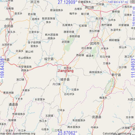
| Upper-left | 27.12909°, | 109.64328° |
| Center: | 26.50158°, | 110.3464° |
| Lower-right: | 25.87062°, | 111.04953° |
| Map W x H: | 139.9×139.9 km | = 86.9×86.9mi |
| max Lat: | 53.31946° ⇑80.5% North |
| Jiangfang: | 26.50158° |
| min Lat: | ⇓19.5% South 18.22056° |
| min Long | Jiangfang | max Long |
| 75.07348° | 110.3464° | 134.28917° |
| W 30.2%⇐ | ⇒69.8% E |
Elevation
Elevation of Jiangfang is 447 m = 1467 ft, and this is 37.8 m = 124 ft below average elevation for this country.
| Max E: |
5622 m = 18445 ft | 28.3% |
| Avg. | 484.8 m = 1591 ft | |
| Jiangfang | 447 m = 1467 ft | |
Min E: |
-3 m = -10 ft | 71.7% |
See also: China elevation on elevation.city.
Geographical zone
Jiangfang is located in North temperate zone (between Tropic of Cancer and the Arctic Circle). Distance of this Northern Tropic circle is 340.8 km =211.8 mi to South.| Distance of | km | miles | from Jiangfang |
|---|---|---|---|
| North Pole | 7060.4 | 4387.1 | to North |
| Arctic Circle | 4454.5 | 2767.9 | to North |
| Tropic Cancer | 340.8 | 211.8 | to South |
| Equator | 2946.7 | 1831 | to South |


Nearby cities:
15 places around Jiangfang: (largest is in red/bold)
• Baimaoping
26.7 km =16.6 mi,  176°
176°
• Changpu
25.1 km =15.6 mi,  289°
289°
• Dankou
18.8 km =11.7 mi,  213°
213°
• Dengyuantai
28.4 km =17.6 mi,  43°
43°
• Guanxia Miaozuxiang
10.5 km =6.5 mi,  318°
318°
• Huangjin Yaozuxiang
22.7 km =14.1 mi,  113°
113°
• Lixiqiao
33.4 km =20.8 mi,  12°
12°
• Malin
29.8 km =18.5 mi,  99°
99°
• Maoping
6.8 km =4.2 mi,  72°
72°
• Qingxi
7.9 km =4.9 mi,  173°
173°
• Rulin
18.9 km =11.7 mi,  204°
204°
• Wuyang
26.9 km =16.7 mi,  356°
356°
• Xiyan
18 km =11.2 mi, 44°
• Zhaishi Miaozu Dongzuxiang
30 km =18.6 mi,  269°
269°
• Zhuzhoujiang Miaozuxiang
33.4 km =20.8 mi,  305°
305°
Sources, notices
• [Note1] Compared only with cities in China existing in our database
• [Src1] Map data: © OpenStreetMap contributors (CC-BY-SA)
• [Src2] Other city data from geonames.org with taken over terms of usage.
• [Src3] Geographical zone / Annual Mean Temperature by Robert A. Rohde @ Wikipedia
