Changpu geodata
Changpu (Hunan) is a seat of a third-order administrative division; located in China in Asia/Shanghai (GMT+8) time zone. In our database, there are 1268 cities with bigger population. Compared to other cities in China, 80.2% of cities are located further ↑North; 70.7% of cities are located further →East and 72.4% of cities have lower elevation than Changpu. Note1


Changpu GPS coordinates[2]
26° 34' 33.024" North, 110° 6' 28.26" East
| Map corner | latitude | longitude |
|---|---|---|
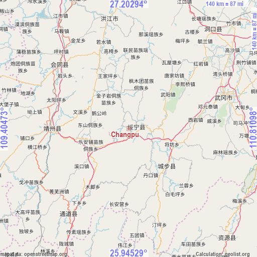
| Upper-left | 27.20294°, | 109.40473° |
| Center: | 26.57584°, | 110.10785° |
| Lower-right: | 25.94529°, | 110.81098° |
| Map W x H: | 139.8×139.8 km | = 86.9×86.9mi |
| max Lat: | 53.31946° ⇑80.2% North |
| Changpu: | 26.57584° |
| min Lat: | ⇓19.8% South 18.22056° |
| min Long | Changpu | max Long |
| 75.07348° | 110.10785° | 134.28917° |
| W 29.3%⇐ | ⇒70.7% E |
Elevation
Elevation of Changpu is 462 m = 1516 ft, and this is 22.8 m = 75 ft below average elevation for this country.
| Max E: |
5622 m = 18445 ft | 27.6% |
| Avg. | 484.8 m = 1591 ft | |
| Changpu | 462 m = 1516 ft | |
Min E: |
-3 m = -10 ft | 72.4% |
See also: China elevation on elevation.city.
Geographical zone
Changpu is located in North temperate zone (between Tropic of Cancer and the Arctic Circle). Distance of this Northern Tropic circle is 349 km =216.9 mi to South.| Distance of | km | miles | from Changpu |
|---|---|---|---|
| North Pole | 7052.1 | 4382 | to North |
| Arctic Circle | 4446.2 | 2762.7 | to North |
| Tropic Cancer | 349 | 216.9 | to South |
| Equator | 2955 | 1836.2 | to South |


Nearby cities:
15 places around Changpu: (largest is in red/bold)
• Chang’anying
34.7 km =21.6 mi,  183°
183°
• Dankou
27.5 km =17.1 mi,  150°
150°
• Dongshan Dongzuxiang
21.1 km =13.1 mi,  275°
275°
• Guanxia Miaozuxiang
16.8 km =10.4 mi,  91°
91°
• Hekou
19 km =11.8 mi,  346°
346°
• Jiangfang
25.1 km =15.6 mi,  109°
109°
• Le’anpu Miaozudongzuxiang
22.3 km =13.9 mi,  246°
246°
• Maoping
30.9 km =19.2 mi,  101°
101°
• Qingxi
29.4 km =18.3 mi,  123°
123°
• Rulin
29.9 km =18.6 mi, 148°
• Tangjiafang
38.9 km =24.2 mi,  40°
40°
• Wuyang
28.7 km =17.8 mi,  49°
49°
• Xiyan
36.6 km =22.7 mi,  82°
82°
• Zhaishi Miaozu Dongzuxiang
10.5 km =6.5 mi,  217°
217°
• Zhuzhoujiang Miaozuxiang
11.6 km =7.2 mi,  342°
342°
Sources, notices
• [Note1] Compared only with cities in China existing in our database
• [Src1] Map data: © OpenStreetMap contributors (CC-BY-SA)
• [Src2] Other city data from geonames.org with taken over terms of usage.
• [Src3] Geographical zone / Annual Mean Temperature by Robert A. Rohde @ Wikipedia
