Huaping geodata
Huaping (Hubei) is a seat of a fourth-order administrative division; located in China in Asia/Shanghai (GMT+8) time zone. In our database, there are 1268 cities with bigger population. Compared to other cities in China, 50.1% of cities are located further ↑North; 71.3% of cities are located further →East and 89.3% of cities have lower elevation than Huaping. Note1


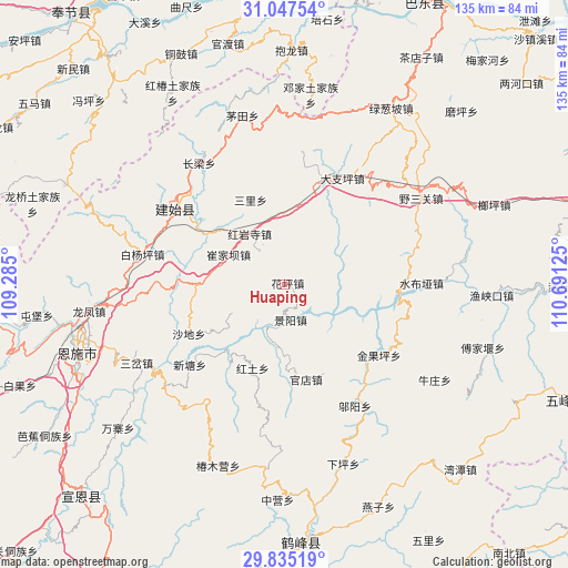
Huaping GPS coordinates[2]
30° 26' 35.7" North, 109° 59' 17.232" East
| Map corner | latitude | longitude |
|---|---|---|
| Upper-left | 31.04754°, | 109.285° |
| Center: | 30.44325°, | 109.98812° |
| Lower-right: | 29.83519°, | 110.69125° |
| Map W x H: | 134.8×134.8 km | = 83.8×83.8mi |
| max Lat: | 53.31946° ⇑50.1% North |
| Huaping: | 30.44325° |
| min Lat: | ⇓49.9% South 18.22056° |
| min Long | Huaping | max Long |
| 75.07348° | 109.98812° | 134.28917° |
| W 28.7%⇐ | ⇒71.3% E |
Elevation
Elevation of Huaping is 1296 m = 4252 ft, and this is 811.2 m = 2661 ft above average elevation for this country.
| Max E: |
5622 m = 18445 ft | 10.7% |
| Huaping | 1296 m 4252 ft | |
| Avg. | 484.8 m = 1591 ft | |
Min E: |
-3 m = -10 ft | 89.3% |
See also: China elevation on elevation.city.
Geographical zone
Huaping is located in North temperate zone (between Tropic of Cancer and the Arctic Circle). Distance of this Northern Tropic circle is 779.1 km =484.1 mi to South.| Distance of | km | miles | from Huaping |
|---|---|---|---|
| North Pole | 6622.1 | 4114.8 | to North |
| Arctic Circle | 4016.2 | 2495.6 | to North |
| Tropic Cancer | 779.1 | 484.1 | to South |
| Equator | 3385 | 2103.3 | to South |


Nearby cities:
15 places around Huaping: (largest is in red/bold)
• Cuijiaba
15.1 km =9.4 mi,  298°
298°
• Dazhiping
28.7 km =17.8 mi,  28°
28°
• Gaoping
26 km =16.2 mi,  19°
19°
• Guandian
23.2 km =14.4 mi,  166°
166°
• Heshuiping
19.8 km =12.3 mi,  319°
319°
• Hongtu
21.4 km =13.3 mi,  201°
201°
• Hongyansi
14.4 km =8.9 mi,  325°
325°
• Jinguoping
28.1 km =17.5 mi,  126°
126°
• Jingyang
8.5 km =5.3 mi, 170°
• Majiagou
28.1 km =17.5 mi, 126°
• Qingtaiping
22.4 km =13.9 mi,  78°
78°
• Sanli
21.6 km =13.4 mi,  338°
338°
• Shadi
25.7 km =16 mi,  242°
242°
• Shangcunba
18 km =11.2 mi,  186°
186°
• Xintang
29.5 km =18.3 mi,  230°
230°
Sources, notices
• [Note1] Compared only with cities in China existing in our database
• [Src1] Map data: © OpenStreetMap contributors (CC-BY-SA)
• [Src2] Other city data from geonames.org with taken over terms of usage.
• [Src3] Geographical zone / Annual Mean Temperature by Robert A. Rohde @ Wikipedia
