Jincheng geodata
Jincheng (Jiangsu) is a seat of a third-order administrative division; located in China in Asia/Shanghai (GMT+8) time zone. In our database, there are 1268 cities with bigger population. Compared to other cities in China, 59.8% of cities are located further ↓South; 79.3% of cities are located further ←West and 86.9% of cities have higher elevation than Jincheng. Note1


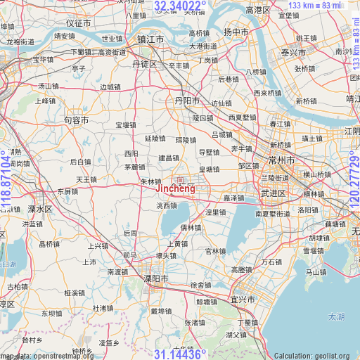
Jincheng GPS coordinates[2]
31° 44' 39.192" North, 119° 34' 26.976" East
| Map corner | latitude | longitude |
|---|---|---|
| Upper-left | 32.34022°, | 118.87104° |
| Center: | 31.74422°, | 119.57416° |
| Lower-right: | 31.14436°, | 120.27729° |
| Map W x H: | 133×133 km | = 82.6×82.6mi |
| max Lat: | 53.31946° ⇑40.2% North |
| Jincheng: | 31.74422° |
| min Lat: | ⇓59.8% South 18.22056° |
| min Long | Jincheng | max Long |
| 75.07348° | 119.57416° | 134.28917° |
| W 79.3%⇐ | ⇒20.7% E |
Elevation
Elevation of Jincheng is 13 m = 43 ft, and this is 471.8 m = 1548 ft below average elevation for this country.
| Max E: |
5622 m = 18445 ft | 86.9% |
| Avg. | 484.8 m = 1591 ft | |
| Jincheng | 13 m = 43 ft | |
Min E: |
-3 m = -10 ft | 13.1% |
See also: China elevation on elevation.city.
Geographical zone
Jincheng is located in North temperate zone (between Tropic of Cancer and the Arctic Circle). Distance of this Northern Tropic circle is 923.7 km =574 mi to South.| Distance of | km | miles | from Jincheng |
|---|---|---|---|
| North Pole | 6477.4 | 4024.9 | to North |
| Arctic Circle | 3871.5 | 2405.6 | to North |
| Tropic Cancer | 923.7 | 574 | to South |
| Equator | 3529.6 | 2193.2 | to South |


Nearby cities:
15 places around Jincheng: (largest is in red/bold)
• Dashu
14.9 km =9.3 mi,  45°
45°
• Erling
15.2 km =9.4 mi,  7°
7°
• Huangli
17.8 km =11.1 mi,  132°
132°
• Huangtang
11.8 km =7.3 mi,  68°
68°
• Jianchang
11.4 km =7.1 mi,  318°
318°
• Jiaze
21 km =13 mi,  107°
107°
• Rulin
17.9 km =11.1 mi,  166°
166°
• Xuebu
17.5 km =10.9 mi,  256°
256°
• Xuebu
19.5 km =12.1 mi, 261°
• Yanling
17.7 km =11 mi,  328°
328°
• Yaotang
10.1 km =6.3 mi, 106°
• Yong’an
13.1 km =8.1 mi,  154°
154°
• Zhiqian
16 km =9.9 mi,  209°
209°
• Zhixi
13.4 km =8.3 mi,  301°
301°
• Zhulin
11.3 km =7 mi,  267°
267°
Sources, notices
• [Note1] Compared only with cities in China existing in our database
• [Src1] Map data: © OpenStreetMap contributors (CC-BY-SA)
• [Src2] Other city data from geonames.org with taken over terms of usage.
• [Src3] Geographical zone / Annual Mean Temperature by Robert A. Rohde @ Wikipedia
