Wanghu geodata
Wanghu (Shanxi) is a seat of a fourth-order administrative division; located in China in Asia/Shanghai (GMT+8) time zone. In our database, there are 1268 cities with bigger population. Compared to other cities in China, 85.7% of cities are located further ↓South; 51.6% of cities are located further →East and 90.9% of cities have lower elevation than Wanghu. Note1


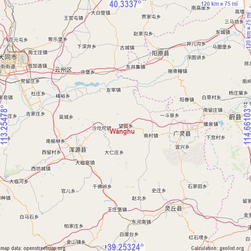
Wanghu GPS coordinates[2]
39° 47' 44.124" North, 113° 57' 28.44" East
| Map corner | latitude | longitude |
|---|---|---|
| Upper-left | 40.3337°, | 113.25478° |
| Center: | 39.79559°, | 113.9579° |
| Lower-right: | 39.25324°, | 114.66103° |
| Map W x H: | 120.1×120.1 km | = 74.6×74.6mi |
| max Lat: | 53.31946° ⇑14.3% North |
| Wanghu: | 39.79559° |
| min Lat: | ⇓85.7% South 18.22056° |
| min Long | Wanghu | max Long |
| 75.07348° | 113.9579° | 134.28917° |
| W 48.4%⇐ | ⇒51.6% E |
Elevation
Elevation of Wanghu is 1448 m = 4751 ft, and this is 963.2 m = 3160 ft above average elevation for this country.
| Max E: |
5622 m = 18445 ft | 9.1% |
| Wanghu | 1448 m 4751 ft | |
| Avg. | 484.8 m = 1591 ft | |
Min E: |
-3 m = -10 ft | 90.9% |
See also: China elevation on elevation.city.
Geographical zone
Wanghu is located in North temperate zone (between Tropic of Cancer and the Arctic Circle). Distance of this Northern Tropic circle is 1818.9 km =1130.2 mi to South.| Distance of | km | miles | from Wanghu |
|---|---|---|---|
| North Pole | 5582.2 | 3468.6 | to North |
| Arctic Circle | 2976.3 | 1849.4 | to North |
| Tropic Cancer | 1818.9 | 1130.2 | to South |
| Equator | 4424.9 | 2749.5 | to South |


Nearby cities:
15 places around Wanghu: (largest is in red/bold)
• Aoshi
19 km =11.8 mi,  2°
2°
• Caicun
27 km =16.8 mi,  257°
257°
• Daciyao
26.3 km =16.3 mi,  228°
228°
• Darenzhuang
13.7 km =8.5 mi,  205°
205°
• Fengyu
33.4 km =20.8 mi,  295°
295°
• Huanghuatan
18.6 km =11.6 mi, 212°
• Huquan
19.2 km =11.9 mi,  90°
90°
• Nanyulin
34 km =21.1 mi, 259°
• Qianfoling
31.1 km =19.3 mi,  201°
201°
• Qingciyao
25.4 km =15.8 mi,  219°
219°
• Wucheng
28.9 km =18 mi,  278°
278°
• Xiahan
30.4 km =18.9 mi,  254°
254°
• Xubu
31.6 km =19.6 mi,  324°
324°
• Yong’an
25.7 km =16 mi,  244°
244°
• Youzai
18.3 km =11.4 mi,  341°
341°
Sources, notices
• [Note1] Compared only with cities in China existing in our database
• [Src1] Map data: © OpenStreetMap contributors (CC-BY-SA)
• [Src2] Other city data from geonames.org with taken over terms of usage.
• [Src3] Geographical zone / Annual Mean Temperature by Robert A. Rohde @ Wikipedia
