Hongde geodata
Hongde (Gansu) is a seat of a fourth-order administrative division; located in China in Asia/Shanghai (GMT+8) time zone. In our database, there are 1268 cities with bigger population. Compared to other cities in China, 78.6% of cities are located further ↓South; 83.1% of cities are located further →East and 89.2% of cities have lower elevation than Hongde. Note1


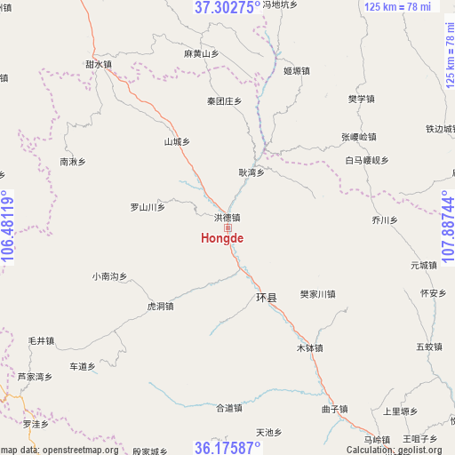
Hongde GPS coordinates[2]
36° 44' 28.968" North, 107° 11' 3.516" East
| Map corner | latitude | longitude |
|---|---|---|
| Upper-left | 37.30275°, | 106.48119° |
| Center: | 36.74138°, | 107.18431° |
| Lower-right: | 36.17587°, | 107.88744° |
| Map W x H: | 125.3×125.3 km | = 77.9×77.9mi |
| max Lat: | 53.31946° ⇑21.4% North |
| Hongde: | 36.74138° |
| min Lat: | ⇓78.6% South 18.22056° |
| min Long | Hongde | max Long |
| 75.07348° | 107.18431° | 134.28917° |
| W 16.9%⇐ | ⇒83.1% E |
Elevation
Elevation of Hongde is 1292 m = 4239 ft, and this is 807.2 m = 2648 ft above average elevation for this country.
| Max E: |
5622 m = 18445 ft | 10.8% |
| Hongde | 1292 m 4239 ft | |
| Avg. | 484.8 m = 1591 ft | |
Min E: |
-3 m = -10 ft | 89.2% |
See also: China elevation on elevation.city.
Geographical zone
Hongde is located in North temperate zone (between Tropic of Cancer and the Arctic Circle). Distance of this Northern Tropic circle is 1479.3 km =919.2 mi to South.| Distance of | km | miles | from Hongde |
|---|---|---|---|
| North Pole | 5921.8 | 3679.6 | to North |
| Arctic Circle | 3315.9 | 2060.4 | to North |
| Tropic Cancer | 1479.3 | 919.2 | to South |
| Equator | 4085.3 | 2538.5 | to South |


Nearby cities:
15 places around Hongde: (largest is in red/bold)
• Bazhu
40.6 km =25.2 mi,  120°
120°
• Fanjiachuan
30.5 km =19 mi,  126°
126°
• Gengwan
16.9 km =10.5 mi,  22°
22°
• Heping
45.7 km =28.4 mi,  187°
187°
• Huancheng
21 km =13 mi,  151°
151°
• Hudong
28.6 km =17.8 mi,  221°
221°
• Luoshanchuan
22 km =13.7 mi,  286°
286°
• Luping
44.5 km =27.7 mi, 194°
• Mubo
39.8 km =24.7 mi, 145°
• Nanqiu
44.6 km =27.7 mi, 293°
• Qiaochuan
43.3 km =26.9 mi,  86°
86°
• Shancheng
27.8 km =17.3 mi,  329°
329°
• Siheyuan
22.5 km =14 mi,  56°
56°
• Xiaonangou
35.2 km =21.9 mi,  248°
248°
• Xichuan
27.5 km =17.1 mi, 186°
Sources, notices
• [Note1] Compared only with cities in China existing in our database
• [Src1] Map data: © OpenStreetMap contributors (CC-BY-SA)
• [Src2] Other city data from geonames.org with taken over terms of usage.
• [Src3] Geographical zone / Annual Mean Temperature by Robert A. Rohde @ Wikipedia
