Huancheng geodata
Huancheng (Gansu) is a seat of a fourth-order administrative division; located in China in Asia/Shanghai (GMT+8) time zone. In our database, there are 1268 cities with bigger population. Compared to other cities in China, 78.4% of cities are located further ↓South; 82.8% of cities are located further →East and 88.6% of cities have lower elevation than Huancheng. Note1


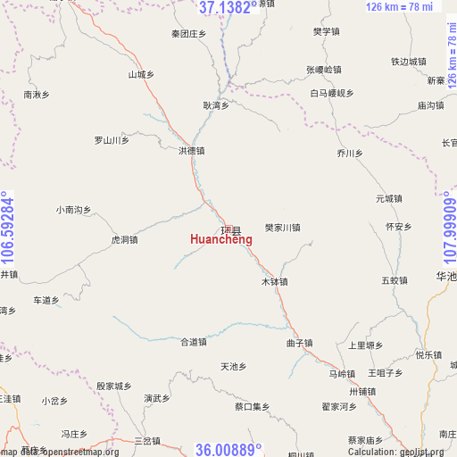
Huancheng GPS coordinates[2]
36° 34' 32.196" North, 107° 17' 45.456" East
| Map corner | latitude | longitude |
|---|---|---|
| Upper-left | 37.1382°, | 106.59284° |
| Center: | 36.57561°, | 107.29596° |
| Lower-right: | 36.00889°, | 107.99909° |
| Map W x H: | 125.6×125.6 km | = 78×78mi |
| max Lat: | 53.31946° ⇑21.6% North |
| Huancheng: | 36.57561° |
| min Lat: | ⇓78.4% South 18.22056° |
| min Long | Huancheng | max Long |
| 75.07348° | 107.29596° | 134.28917° |
| W 17.2%⇐ | ⇒82.8% E |
Elevation
Elevation of Huancheng is 1235 m = 4052 ft, and this is 750.2 m = 2461 ft above average elevation for this country.
| Max E: |
5622 m = 18445 ft | 11.4% |
| Huancheng | 1235 m 4052 ft | |
| Avg. | 484.8 m = 1591 ft | |
Min E: |
-3 m = -10 ft | 88.6% |
See also: China elevation on elevation.city.
Geographical zone
Huancheng is located in North temperate zone (between Tropic of Cancer and the Arctic Circle). Distance of this Northern Tropic circle is 1460.9 km =907.8 mi to South.| Distance of | km | miles | from Huancheng |
|---|---|---|---|
| North Pole | 5940.2 | 3691.1 | to North |
| Arctic Circle | 3334.3 | 2071.8 | to North |
| Tropic Cancer | 1460.9 | 907.8 | to South |
| Equator | 4066.8 | 2527 | to South |


Nearby cities:
15 places around Huancheng: (largest is in red/bold)
• Baima
38.4 km =23.9 mi,  86°
86°
• Bazhu
25 km =15.5 mi,  95°
95°
• Fanjiachuan
14.7 km =9.1 mi, 88°
• Gengwan
34.2 km =21.3 mi,  354°
354°
• Hedao
32.4 km =20.1 mi,  197°
197°
• Heping
31.3 km =19.4 mi,  211°
211°
• Hongde
21 km =13 mi,  331°
331°
• Hudong
29.1 km =18.1 mi,  264°
264°
• Luping
32.6 km =20.3 mi,  220°
220°
• Mubo
19.1 km =11.9 mi,  138°
138°
• Quzi
36.9 km =22.9 mi,  148°
148°
• Siheyuan
32 km =19.9 mi,  16°
16°
• Tianchi
37.7 km =23.4 mi,  177°
177°
• Xichuan
15.8 km =9.8 mi,  235°
235°
• Xujiahe
37.1 km =23.1 mi,  134°
134°
Sources, notices
• [Note1] Compared only with cities in China existing in our database
• [Src1] Map data: © OpenStreetMap contributors (CC-BY-SA)
• [Src2] Other city data from geonames.org with taken over terms of usage.
• [Src3] Geographical zone / Annual Mean Temperature by Robert A. Rohde @ Wikipedia
