Gengwan geodata
Gengwan (Gansu) is a seat of a fourth-order administrative division; located in China in Asia/Shanghai (GMT+8) time zone. In our database, there are 1268 cities with bigger population. Compared to other cities in China, 78.9% of cities are located further ↓South; 82.9% of cities are located further →East and 89.5% of cities have lower elevation than Gengwan. Note1


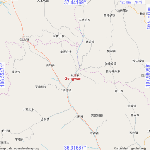
Gengwan GPS coordinates[2]
36° 52' 52.86" North, 107° 15' 28.188" East
| Map corner | latitude | longitude |
|---|---|---|
| Upper-left | 37.44169°, | 106.55471° |
| Center: | 36.88135°, | 107.25783° |
| Lower-right: | 36.31687°, | 107.96096° |
| Map W x H: | 125.1×125.1 km | = 77.7×77.7mi |
| max Lat: | 53.31946° ⇑21.1% North |
| Gengwan: | 36.88135° |
| min Lat: | ⇓78.9% South 18.22056° |
| min Long | Gengwan | max Long |
| 75.07348° | 107.25783° | 134.28917° |
| W 17.1%⇐ | ⇒82.9% E |
Elevation
Elevation of Gengwan is 1313 m = 4308 ft, and this is 828.2 m = 2717 ft above average elevation for this country.
| Max E: |
5622 m = 18445 ft | 10.5% |
| Gengwan | 1313 m 4308 ft | |
| Avg. | 484.8 m = 1591 ft | |
Min E: |
-3 m = -10 ft | 89.5% |
See also: China elevation on elevation.city.
Geographical zone
Gengwan is located in North temperate zone (between Tropic of Cancer and the Arctic Circle). Distance of this Northern Tropic circle is 1494.9 km =928.9 mi to South.| Distance of | km | miles | from Gengwan |
|---|---|---|---|
| North Pole | 5906.2 | 3669.9 | to North |
| Arctic Circle | 3300.4 | 2050.8 | to North |
| Tropic Cancer | 1494.9 | 928.9 | to South |
| Equator | 4100.8 | 2548.1 | to South |


Nearby cities:
15 places around Gengwan: (largest is in red/bold)
• Baima
52.4 km =32.6 mi,  127°
127°
• Bazhu
46.1 km =28.6 mi,  142°
142°
• Fanjiachuan
38.1 km =23.7 mi,  151°
151°
• Hongde
16.9 km =10.5 mi,  202°
202°
• Huancheng
34.2 km =21.3 mi,  174°
174°
• Hudong
44.9 km =27.9 mi,  214°
214°
• Luoshanchuan
29.2 km =18.1 mi,  251°
251°
• Mubo
50.9 km =31.6 mi,  161°
161°
• Nanqiu
47.6 km =29.6 mi,  272°
272°
• Qiaochuan
38.9 km =24.2 mi,  109°
109°
• Shancheng
22.2 km =13.8 mi,  292°
292°
• Siheyuan
12.7 km =7.9 mi,  104°
104°
• Tiebiancheng
53.8 km =33.4 mi,  77°
77°
• Xiaonangou
48.5 km =30.1 mi,  233°
233°
• Xichuan
44 km =27.3 mi,  192°
192°
Sources, notices
• [Note1] Compared only with cities in China existing in our database
• [Src1] Map data: © OpenStreetMap contributors (CC-BY-SA)
• [Src2] Other city data from geonames.org with taken over terms of usage.
• [Src3] Geographical zone / Annual Mean Temperature by Robert A. Rohde @ Wikipedia
