Siheyuan geodata
Siheyuan (Gansu) is a seat of a fourth-order administrative division; located in China in Asia/Shanghai (GMT+8) time zone. In our database, there are 1268 cities with bigger population. Compared to other cities in China, 78.8% of cities are located further ↓South; 82.5% of cities are located further →East and 92.9% of cities have lower elevation than Siheyuan. Note1


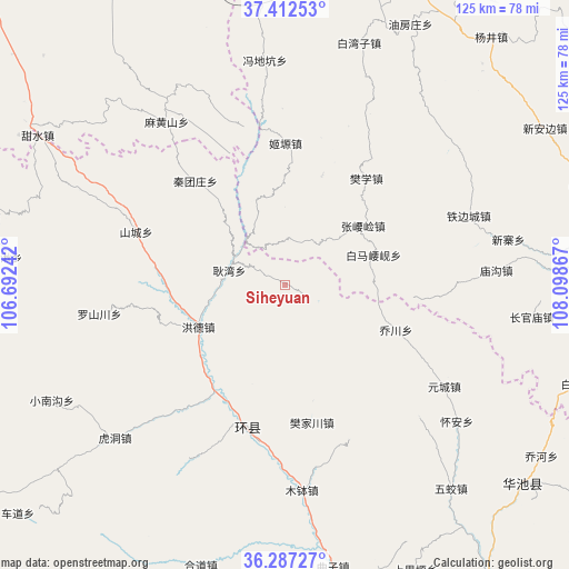
Siheyuan GPS coordinates[2]
36° 51' 7.092" North, 107° 23' 43.944" East
| Map corner | latitude | longitude |
|---|---|---|
| Upper-left | 37.41253°, | 106.69242° |
| Center: | 36.85197°, | 107.39554° |
| Lower-right: | 36.28727°, | 108.09867° |
| Map W x H: | 125.1×125.1 km | = 77.7×77.7mi |
| max Lat: | 53.31946° ⇑21.2% North |
| Siheyuan: | 36.85197° |
| min Lat: | ⇓78.8% South 18.22056° |
| min Long | Siheyuan | max Long |
| 75.07348° | 107.39554° | 134.28917° |
| W 17.5%⇐ | ⇒82.5% E |
Elevation
Elevation of Siheyuan is 1695 m = 5561 ft, and this is 1210.2 m = 3970 ft above average elevation for this country.
| Max E: |
5622 m = 18445 ft | 7.1% |
| Siheyuan | 1695 m 5561 ft | |
| Avg. | 484.8 m = 1591 ft | |
Min E: |
-3 m = -10 ft | 92.9% |
See also: China elevation on elevation.city.
Geographical zone
Siheyuan is located in North temperate zone (between Tropic of Cancer and the Arctic Circle). Distance of this Northern Tropic circle is 1491.6 km =926.8 mi to South.| Distance of | km | miles | from Siheyuan |
|---|---|---|---|
| North Pole | 5909.5 | 3672 | to North |
| Arctic Circle | 3303.6 | 2052.8 | to North |
| Tropic Cancer | 1491.6 | 926.8 | to South |
| Equator | 4097.6 | 2546.1 | to South |


Nearby cities:
15 places around Siheyuan: (largest is in red/bold)
• Baima
41 km =25.5 mi,  134°
134°
• Bazhu
36.8 km =22.9 mi,  154°
154°
• Fanjiachuan
30.8 km =19.1 mi,  169°
169°
• Gengwan
12.7 km =7.9 mi,  284°
284°
• Hongde
22.5 km =14 mi,  236°
236°
• Huai’an
48.1 km =29.9 mi, 128°
• Huancheng
32 km =19.9 mi,  196°
196°
• Luoshanchuan
40.4 km =25.1 mi,  261°
261°
• Miaogou
46.5 km =28.9 mi,  86°
86°
• Mubo
45.3 km =28.1 mi,  175°
175°
• Qiaochuan
26.3 km =16.3 mi,  111°
111°
• Shancheng
34.8 km =21.6 mi,  289°
289°
• Tiebiancheng
43 km =26.7 mi,  69°
69°
• Xichuan
45.3 km =28.1 mi,  208°
208°
• Yuancheng
41.6 km =25.8 mi,  122°
122°
Sources, notices
• [Note1] Compared only with cities in China existing in our database
• [Src1] Map data: © OpenStreetMap contributors (CC-BY-SA)
• [Src2] Other city data from geonames.org with taken over terms of usage.
• [Src3] Geographical zone / Annual Mean Temperature by Robert A. Rohde @ Wikipedia
